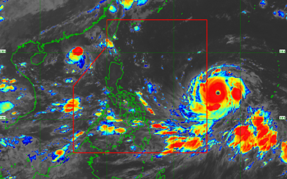
MANILA -- Typhoon "Mangkhut" gains strength as it moves closer and expected to enter the Philippine Area of Responsibility (PAR) Wednesday afternoon.
Philippine Atmospheric, Geophysical and Astronomical Services Administration (PAGASA) weather forecaster Chris Perez said that as of 3 a.m., "Mangkhut" which will be named "Ompong" once it enters the country, was last observed 1,390 kilometers east of southern Luzon.
The brewing typhoon in the Pacific has maximum sustained winds of 220 kms per hour near the center, gusts of 245 kph and moves west at 20 kph.
Moderate to heavy rain is expected across Luzon and some parts of the country starting Wednesday until the weekend.
Meanwhile, Perez said the southwest monsoon continues to affect the western section of the country, particularly Palawan, western Visayas and Zamboanga peninsula.
Metro Manila and the rest of the country will have cloudy skies with isolated rain showers due to localized thunderstorm.
He said typhoon "Barijat" (formerly "Neneng") is now out of PAR at 550 kms west of Basco, Batanes and does not have direct effect in the country.
Temperature in Metro Manila ranges from 25-32 degrees Celsius, Baguio City 15-21, Tagaytay City 21-28, Iloilo City 25-31, Metro Cebu 24-32, and Metro Davao at 24-32. (PNA)
