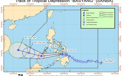
MANILA -- Tropical Depression "Basyang" has weakened Tuesday afternoon as it moved towards the Bohol Sea, according to the Philippine Atmospheric, Geophysical and Astronomical Services Administration (PAGASA).
In its 5-p.m. weather bulletin, PAGASA said "Basyang" was estimated 25 kilometers southeast of Tagbilaran City, Bohol, packing winds of 45 kilometers per hour and gustiness of up to 65 kph. It is projected to move west at 27 kph.
PAGASA raised Signal No. 1 over Palawan, Aklan, Capiz, Antique, Iloilo, Guimaras, Negros Occidental, Negros Oriental, Siquijor, Bohol, Cebu, Biliran, Leyte, Southern Leyte, Camiguin, Misamis Oriental, Misamis Occidental, and the northern section of Zamboanga del Norte. These areas will experience 30-60 kph winds within the next 36 hours.
Warning signals in other areas have been lifted.
TD Basyang is also expected to be 90 km south-southwest of Puerto Princesa City, Palawan on Wednesday afternoon and outside the Philippine Area of Responsibility (PAR) on Thursday afternoon.
The weather bureau also forecasts scattered to widespread moderate to heavy rains over Palawan and Visayas in the next 24 hours.
PAGASA cautioned of possible flooding and landslides in these areas.
Zamboanga Peninsula, Northern Mindanao, Caraga, and the provinces of Basilan, Sulu, and Tawi-Tawi are also expected to have scattered light to moderate with occasional heavy rains. PAGASA similarly warned of possible flooding and landslides in these areas.
The weather bureau also warned of risky travel over the areas under Signal No. 1, seaboards of northern Luzon and Visayas, eastern seaboards of Central Luzon and Mindanao, eastern and southern seaboards of Southern Luzon due to the tropical depression and the surge of the northeast monsoon. (PNA)
