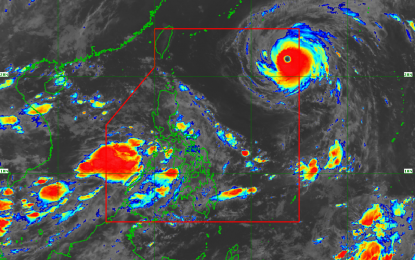
'GARDO' IN PH. Typhoon "Gardo" enters the Philippine Area of Responsibility on Monday morning. (Satellite image courtesy of PAGASA)
MANILA -- Typhoon "Gardo" (international name Maria) has entered the Philippine Area of Responsibility (PAR) Monday morning, the Philippine Atmospheric, Geophysical and Astronomical Services Administration (Pagasa) said.
In its latest forecast at 4 a.m. Monday, Pagasa said Gardo was last observed 1,325 kilometers east of Basco, Batanes, with maximum sustained winds of 200 kph near the center and gustiness of 245 kph.
Gardo, which is not expected to make landfall over the country, is moving west-northwest at 30 kph.
Gardo is expected to enhance the southwest monsoon and bring rains over the regions of Mimaropa and Western Visayas and occasional rains over Metro Manila, regions of Calabarzon, Bicol, and the provinces of Zambales, Bataan, and Aurora until Tuesday (July 10).
Pagasa added that monsoon rains would affect most of Luzon, especially over the western section, beginning Wednesday (July 10).
The state weather bureau has cautioned residents of flooding and landslides, especially those living in low-lying and mountainous areas.
Fishermen are advised against going out as sea travel is risky over the northern and eastern seaboards of northern Luzon. (PNA)
