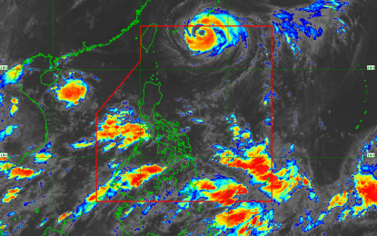
RAINY TUESDAY. Typhoon “Gardo” (international name Maria) will continue to enhance the southwest monsoon or "habagat" Tuesday as it moves outside the Philippine Area of Responsibility. (Satellite image courtesy of PAGASA)
MANILA -- Typhoon “Gardo” (international name Maria) would continue to enhance the southwest monsoon or "habagat" Tuesday, bringing scattered rains and thunderstorms in most parts of the country, state weather bureau Philippine Atmospheric, Geophysical and Astronomical Services Administration (PAGASA) said.
In its 4 a.m. forecast, PAGASA said "Gardo" is moving west northwest at 30 km. per hour (kph) out of the Philippine Area of Responsibility (PAR). It was last observed at 760 km. northwest of Basco, Batanes with maximum winds of 120 kph near the center and gustiness of up to 210 kph.
"Gardo" is expected to exit the PAR Tuesday night or Wednesday morning, PAGASA said.
The southwest monsoon continues to affect Luzon and Visayas and would bring rains in Metro Manila, the provinces of Palawan, Mindoro, Romblon, Zambales, Pampanga, Bulacan, Cavite, Batangas and Bataan.
The rest of Luzon and western Visayas would also get cloudy skies with scattered rains and thunderstorms brought about by southwest monsoon.
Fishermen are advised against going out to sea as coastal waters in the northern and eastern section seaboard of northern Luzon would be rough to very rough.
The temperature in Metro Manila ranges from 25-29 degrees Celsius; Tuguegarao City 24-32 degrees Celsius; Baguio City 16-22 degrees Celsius; Metro Cebu 25-33 degrees Celsius and Metro Davao 25-33 degrees Celsius. (PNA)
