(Photo from PAGASA website)
MANILA -- Typhoon "Hanna" (International name Lekima) will bring light to moderate rains and gusty winds over Batanes and the Babuyan Group of Islands tonight until Thursday, according to the Philippine Atmospheric, Geophysical and Astronomical Services Administration (PAGASA).
In its 5 p.m. forecast, PAGASA said moderate to heavy monsoon rains will continue over the northern portions of Palawan (including the Calamian and Cuyo Islands), Occidental Mindoro, Oriental Mindoro, Romblon, Zambales, Bataan, Aklan, Antique, Iloilo and Guimaras Wednesday night.
On the other hand, light to moderate rains will prevail over Metro Manila and the rest of Luzon and Western Visayas.
On Thursday, the weather bureau said moderate to heavy monsoon rains may affect Metro Manila, Ilocos Region, Cordillera Administrative Region, Zambales, Bataan, Rizal, Cavite, Laguna, Batangas, Occidental Mindoro, Oriental Mindoro, and the northern portions of Palawan, including Calamian and Cuyo Islands.
Light to moderate rains may also prevail over Western Visayas and the rest of Luzon, it added.
Residents in these areas, especially those living in areas identified to be highly or very highly susceptible to floods and rain-induced landslides, are advised to take precautionary measures, coordinate with local disaster risk reduction and management offices, and continue monitoring for updates.
Occasional gusty conditions will continue over the western sections of Luzon and Visayas due to the enhanced Southwest Monsoon.
As such, sea travel is risky over the seaboards of Luzon and Visayas, and the northern and eastern seaboards of Mindanao due to potentially rough sea conditions.
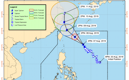
PAGASA said "Hanna" will continue to intensify as it moves closer toward the southern Ryukyu Islands.
It will less likely to make landfall on any part of the country and is expected to exit the Philippine Area of Responsibility (PAR) on Friday (August 9).
Meanwhile, at 4 p.m. Wednesday, the low-pressure area (LPA) was estimated at 325 km. west of Dagupan City, Pangasinan.
The weather bureau said this weather disturbance remains less likely to develop into a tropical depression. (PNA)
