(Photo courtesy of PAGASA website)
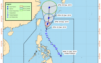
MANILA -- Tropical storm (TS) "Liwayway" continues to intensify, and will bring light to moderate with intermittent heavy rains over Batanes and Babuyan Group of Islands likely until Wednesday, the weather bureau said Tuesday afternoon.
"Liwayway" was last tracked at a 225 km. east of Basco, Batanes, heading north at 15 kph.
It packs a maximum sustained winds of 110 kph near the center, and gustiness of up to 135 kph.
The Philippine Atmospheric, Geophysical and Astronomical Services Administration (PAGASA) expects Liwayway to leave the Philippine Area of Responsibility either Wednesday night or Thursday morning.
The TS is not expected to make landfall in the Philippines, it added.
Meanwhile, tropical cyclone warning signal no. 1 was raised over Batanes. Residents of Batanes and Babuyan Group of Islands are warned against possible flooding and strong winds.
Light to moderate winds with at times heavy rain showers will prevail over Metro Manila, Calabarzon, Central Luzon, Ilocos Region, northern portion of Palawan, Mindoro and the rest of Cordillera Administrative Region due to the southwest monsoon affecting Luzon and western Visayas.
The rest of the country will have isolated rain showers caused by localized thunderstorms.
Strong winds will blow over northern and central Luzon, and the western part of southern Luzon. Sea travel is risky over the seaboards of Luzon, according to PAGASA.
Moderate to strong winds will prevail over Visayas and the rest of Luzon, where waters will be moderate to rough.
Over Mindanao, winds will be light to moderate with slight to moderate seas, PAGASA said. (PNA)
