(Graphic taken from PAGASA website)
MANILA -- Several areas in Luzon and Visayas are under tropical cyclone wind signal (TCWS) no. 1 and 2 as tropical storm "Ramon" maintains its strength, the weather bureau said Thursday afternoon.
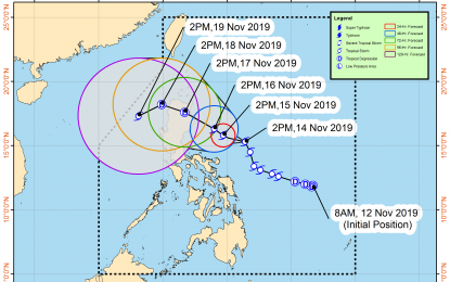
Ramon was last eyed 500 kilometers east of Baler, Aurora, heading north-northwest at 15 kph. It has maximum sustained winds of 65 kph near the center, and gustiness of up to 80 kph, according to the Philippine Atmospheric, Geophysical and Astronomical Services Administration (PAGASA).
TCWS no. 2 was raised over Catanduanes, while the eastern portion of Isabela (Divilacan, Palanan, Dinapigue), Northern Aurora (Dilasag, Casiguran, Dinalungan), Polillo Island, Camarines Norte, Camarines Sur, and Albay were put under TCWS no. 1.
Light to moderate with occasional heavy rains may be experienced over the eastern portion of Cagayan and Isabela, and light to moderate with intermittent heavy rains will prevail over Northern Aurora, Camarines Norte, and Polillo Island, likely until Friday.
On Saturday, PAGASA forecast light to moderate to occasionally heavy rains over Cagayan, northern Aurora, and the eastern portion of Isabela. Light to moderate with intermittent heavy rains may also be experience over Apayao and the rest of Isabela and Aurora.
Sea travel is risky, especially for small sea crafts, over the seaboards of areas under the typhoon signal. This includes the seaboards of northern Luzon, and the eastern seaboards of Aurora and Quezon due to prevailing or forecast rough sea conditions, PAGASA said. (PNA)
