(Image taken from PAGASA FB page)
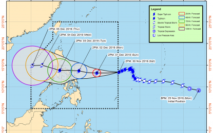
MANILA -- Typhoon Kammuri has entered the Philippine Area of Responsibility (PAR) and was named "Tisoy", the weather bureau reported Saturday afternoon.
"Tisoy" was last seen 1,165 kilometers east of Virac, Catanduanes, moving west southwest at 15 kph, according to the Philippine Atmospheric, Geophysical and Astronomical Services Administration (PAGASA).
It has maximum sustained winds of up to 150 kph near the center and gustiness of up to 185 kph.
Tropical cyclone wind signal (TCWS) no. 1 was raised over Eastern Samar, and eastern section of Northern Samar (Laoang, Palapag, Mapanas, Gamay, Lapinig, Catubig, and Las Navas).
PAGASA expects occasional to frequent heavy rains over Bicol Region, Samar provinces, and Biliran.
Moderate to occasionally heavy rains may prevail over Romblon, Marinduque, and Quezon.
Residents of the aforementioned areas, especially those in areas identified to be highly susceptible to flooding and rain-induced landslides, are advised to take appropriate actions.
Meanwhile, sea travel is risky, especially for small sea crafts, over the seaboards of areas under TCWS, the northern and western seaboards of northern Luzon, and the eastern seaboards of the country due to prevailing or forecast rough sea conditions.
PAGASA forecast "Tisoy" to make landfall over Bicol Region between Monday and Tuesday. (PNA)
