(Image taken from PAGASA Facebook page)
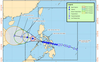
MANILA -- Typhoon "Ursula" has maintained its strength while traversing the northern tip of the Aklan-Antique area at 20 kph, the weather bureau said on Wednesday afternoon.
The Philippine Atmospheric, Geophysical and Astronomical Services Administration (PAGASA) said Ursula was packing maximum sustained winds of 140 kph near the center, and gustiness of up to 195 kph.
The eyewall of the typhoon "is bringing very destructive winds and intense rainfall over Caluya Islands. The southern portion of Mindoro provinces will be affected by the eyewall in the coming hours. In case of the passage of the eye in some of the aforementioned areas, calm conditions will be experienced. However, as soon as the eye moves out of the area, violent conditions associated with the eyewall will resume," PAGASA reported in its 2 p.m. bulletin.
Tropical Cyclone Wind Signal (TCWS) No. 3 has been raised over Romblon, southern Oriental Mindoro (Roxas, Mansalay, Bulalacao, Bongabong, Bansud, Pola, Socorro, Pinamalayan, Gloria), southern Occidental Mindoro (Calintaan, Rizal, San Jose, Magsaysay, southern portion of Sablayan), and Calamian Islands (Busuanga, Coron, Culion).
Batangas, Marinduque, the rest of Oriental Mindoro, the rest of Occidental Mindoro including Lubang Island, Cuyo Islands, the extreme northern portion of mainland Palawan (Linapacan, El Nido, Taytay, Araceli), Capiz, Aklan, and northern Antique (Caluya, Libertad, Pandan, Sebaste, Culasi, Tibiao, Barbaza, Laua-an) have been put under TCWS No. 2.
TCWS No. 1 has been raised over Bataan, Metro Manila, Rizal, Cavite, Laguna, the rest of northern mainland Palawan (Dumaran, San Vicente, Roxas), Cagayancillo Islands, Camarines Norte, Camarines Sur, Quezon, Albay, Masbate including Burias and Ticao Islands, Northern Negros Occidental (Hinigaran, La Castellana, Pontevedra, La Carlota, San Enrique, Valladolid, Pulupandan, Bago, Murcia, Bacolod, Talisay, Salvador Benedicto, Silay, Enrique B. Magalona, Victorias, Manapla, Cadiz, Sagay, Escalante, Toboso, Calatrava), Iloilo, Guimaras, and the rest of Antique.
Occasional to frequent heavy with intermittent intense rains will prevail over Aklan, Antique, Capiz, Romblon, Calamian Islands, Cuyo Islands, and Mindoro provinces until Christmas night.
Light to moderate rains with isolated heavy rain showers during thunderstorms will be experienced over the Bicol region, the rest of Western Visayas, Calabarzon, Metro Manila, Marinduque, Aurora, and the northern portion of mainland Palawan, also until the evening.
Residents of these areas have been advised to take appropriate measures to reduce the potential impact of flooding and rain-induced landslides.
Meanwhile, moderate to strong winds will affect Metro Manila and Bataan between afternoon and early evening.
Damaging gale to storm-force winds will affect Batangas in the afternoon or early evening.
Destructive typhoon-force winds were also forecast to affect the Mindoro provinces in the afternoon; and the Calamian islands between afternoon and evening.
Rough sea conditions will prevail over the seaboards of areas under TCWS, as well the seaboards of Aurora, and the northern and eastern seaboards of Mindanao. Sea travel remains risky over these areas, PAGASA said. (PNA)
