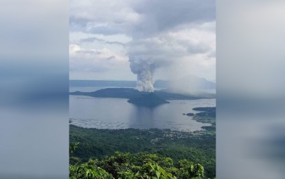
TOTAL EVACUATION. The Philippine Institute of Volcanology and Seismology officials reiterate the need for total evacuation from high-risk areas, as Taal Volcano remains on Alert Level 4. This level has been raised over the volcano since January 13, which means that hazardous explosive eruption is possible within hours or days. (PNA file photo by Joey Razon)
MANILA -- A week after Taal Volcano's eruption, Philippine Institute of Volcanology and Seismology (Phivolcs) director Renato Solidum Jr. on Monday reminded that total evacuation is necessary in the identified "danger zone", as the volcano remains on Alert Level 4 (hazardous explosive eruption is possible within hours to days).
"Just a reminder that total evacuation is advised to those in high-risk areas -- the 14-kilometer radius from Taal Main Crater, and along the Pansipit River where fissures have been observed," he said in a briefing.
Taal Volcano remains on Alert Level 4, and the possibility of a strong eruption also remains, he noted.
From 5 a.m. Sunday until 5 a.m. Monday, Phivolcs recorded 23 volcanic earthquakes, with magnitudes 1.2 to 3.8.
Solidum said the magnitude 4.6 quake that hit Mabini, Batangas on Sunday night was caused by fault movements. This fault started moving during the April 2017 series of earthquakes, he added.
"We would study whether this (magnitude 4.6) earthquake has an effect on the volcano and vice versa. But for now, since there was fault movement, definitely magma would be pushed upward," Solidum said.
Phivolcs have registered sulfur dioxide (SO2) emission at an average of 4,353 tonnes per day (from 5 a.m. of January 19 to 5 a.m. of January 20), higher than the 1,442 SO2 emission it recorded from January 18, 5 a.m. to January 19, 5 a.m.
"If the sulfur dioxide is higher, it means there's magma going up. If you would compare to other volcanoes, the more gas present means there is more magma," Solidum explained.
Meanwhile, according to Phivolcs, steady steam emission and infrequent weak explosions that generated ash plumes 500 to 1,000 meters tall were observed for the past 24 hours.
The Philippine Atmospheric, Geophysical and Astronomical Services Administration (PAGASA) forecast that if the plume rises between three to five kilometers, ash will be drifted to parts of Cavite. If major eruption occurs and eruption column exceeds five kilometers, ash will also be drifted to Metro Manila, Laguna, parts of Rizal and northern Quezon, it added. (PNA)
