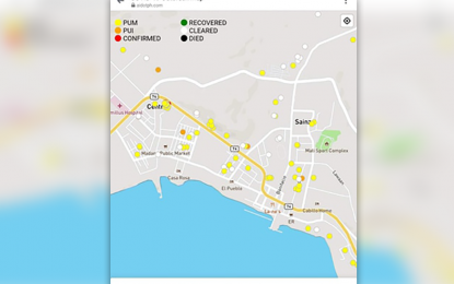
MONITORING. The color coded Heat map of the 2019 coronavirus disease (Covid-19) patients within the City of Mati in Davao Oriental. A heat map mobile application shows real-time location within a 50-meter radius. (Courtesy of Mati CIO)
DAVAO CITY – The City of Mati in Davao Oriental has stepped up the monitoring of coronavirus disease 2019 (Covid-19) patients through a mobile application that shows their real-time location within a 50-meter radius.
In a statement on Thursday, Mati City’s Information Office underscored the need to monitor not only Covid-19 patients but also persons under monitoring (PUMs) and patients under investigation (PUIs) to make the public aware of their location so they could take the necessary health precautions.
Developed by Al Francis Delagua of Artificial Intelligence PH (AI.PH), the mobile app is being used by the Mati City Incident Management Team (IMT) Covid-19 to map out the locations of PUIs, PUMs, and Covid-19 patients and give the city government a clearer picture of the Covid-19 infections and suspected cases.
AI.PH was also responsible for the mobile app used by distressed overseas Filipino workers (OFW) in the Middle East so they could readily inform the Philippine Embassy of their situation.
The app enables embassy officials to pinpoint the exact location of the distressed OFW for an easy and expeditious rescue.
Delagua said that aside from the location of PUMs, PUIs, and Covid-19-positive patients, the mobile app gives the location information of those already cleared and those who have died of the disease.
“With the Data Privacy Act, information of the patients, like the name, age, and other details will not be accessible to the public. With the app, at least the movement will be monitored and information will be color-coded,” he said.
The IMT's contact tracing team will input details of the PUMs, PUIs, and positive patients through the mobile app.
The information on their location will readily show up in the mobile app for public access.
As to the security of the data, Delagua said they have employed security measures on the app to prevent possible hacking.
He added that data accuracy would depend on the health workers who would input the information on the mobile app.
Mati IMT-Covid-19 commander, Dr. Ben Hur Catbagan Jr., acknowledged the importance of the mobile app, saying it would give them full control of the PUMs, PUIs, and positive patients in terms of monitoring.
For instance, Catbagan said that in case the city government decides to implement lockdowns on specific areas, they could readily identify which areas to quarantine from the barangay down to the sitios.
"This gives the IMT full control of the situation. And we can readily act on any report of possible violations of the quarantine protocols," he said. (PNA)
------------
MONITORING. Photo shows the color-coded heat map of Covid-19 patients in Davao Oriental. A heat map mobile application can show real-time location within a 50-meter radius. (Graphic courtesy of Mati CIO)
