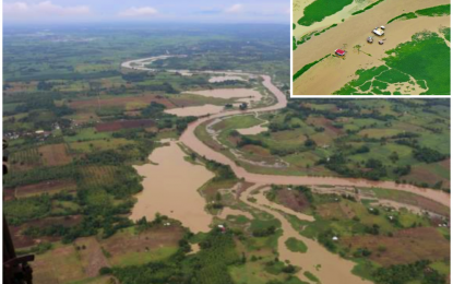
AERIAL VIEW. The flooded communities of North Cotabato beside the Rio Grande de Mindanao, a river that crisscrosses North Cotabato and Maguindanao provinces as viewed from above by North Governor Nancy Catamco aboard a Philippine Air Force chopper. The aerial survey gave provincial officials cognizance of the effects of natural calamities (inset) to constituents, infrastructure, and agriculture. (Photo courtesy of North Cotabato PIO)
COTABATO CITY – North Cotabato Governor Nancy Catamco has sought the help of national government agencies to help the province recover from the damages to agriculture lands and farm-to-market roads caused by flooding since the first week of August, and mitigate similar incidents during this rainy season.
“We need the support of DPWH (Department of Public Works and Highways) and NIA (National Irrigation Administration) in establishing embankment support for bridges and prevention of soil erosion as well as clearing of dams with debris,” the governor said in a statement following the aerial survey.
With the help of a Philippine Air Force (PAF) chopper, Catamco on Saturday conducted an aerial survey of the flooded areas of the province to determine what government interventions can be taken.
Accompanying the governor in the chopper were Provincial Engineer Jun Duyungan, Provincial Disaster Risk Reduction and Management Council (PDRRMC) Emergency Operations Chief Arnulfo Villaruz, Brig. Gen. Anthony Cacayuran, 54th Army Engineering Brigade commander, and Brig. Gen. Roberto Capulong, 602nd Infantry Brigade commander.
From the chopper, Catamco had the bird’s eye view of the flooded communities in at least eight towns.
The PAF chopper flew over the towns of Midsayap, Pigcawayan, Pikit, M’lang, Libungan, Kabacan, and portions of Matalam as well as the landslide areas in Libungan and Alamada.
Villaruz said that the aerial survey revealed that the water levels of rivers were "a little above normal."
He said if upstream areas like Bukidnon province will experience two or three days of continuous rains, it would result in massive flooding in North Cotabato before the water reaches the Liguasan marshland.
"It is anticipated that chest-deep floodwaters might be experienced in some areas,” Villaruz said, adding that such scenario would mean the massive evacuation of affected residents.
Farmers in flood-prone areas are advised to harvest early and the planting season should be guided by climate forecast, Villaruz added.
He then advocated the use of “Go Bag”, which he said should be ready in all households during the rainy season.
“Go Bag” is a carrier sack that contains important items that a family needs in case evacuation is advised.
The bag should include a first aid kit, flashlight, extra batteries, matches in a waterproof container, and a whistle. It also may be helpful to have strong tape, plastic sheeting, and a few tools.
“This should sustain the family for three days while the local government unit's help is being prepared,” Villaruz said.
Catamco said what she personally witnessed in the aerial survey will be discussed in the provincial development council to ensure people, infrastructure and agriculture crops are safe. (PNA)
