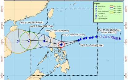
(Courtesy of PAGASA)
MANILA – Typhoon Rolly continues to move towards Luzon from 540 km. east-northeast of Virac, Catanduanes, pouring rains and bringing gusty winds over parts of the country.
In a severe weather bulletin on Saturday, the Philippine Atmospheric, Geophysical and Astronomical Services Administration (PAGASA) said "Rolly" will continue to move west-southwestward towards the sea off the coast of the Bicol region at 20 kph before turning west-northwestward early Sunday.
It has maximum sustained winds of 215 kph near the center and gustiness of up to 265 kph.
“The center of the eye of the typhoon is forecast to pass very close to Catanduanes tomorrow early morning, over the Calaguas Islands and very close to mainland Camarines provinces tomorrow morning, and over the Polillo Islands and mainland Quezon tomorrow afternoon or early evening,” PAGASA said.
It did not rule out the possibility of “Rolly” making landfall over Catanduanes and the Camarines provinces.
The bureau said “Rolly” could reach the Super Typhoon category over the next 12 hours, most likely to be near Super Typhoon strength (185 kph to 215 kph) by the time it grazes Bicol and makes landfall over Quezon.
“During its traverse over Luzon, 'Rolly' is forecast to weaken considerably and emerge as a severe tropical storm or minimal typhoon over the West Philippine Sea,” it said.
From late evening Saturday though Sunday, “Rolly’s” passage will bring heavy to intense rains over Catanduanes, Camarines Norte, Camarines Sur, Albay, Burias Island, Calabarzon, Metro Manila, Bulacan, Pampanga, Bataan, Zambales, and Tarlac.
Moderate to heavy rains will be experienced over Marinduque, Romblon, Occidental Mindoro, Oriental Mindoro, Northern Samar, mainland Cagayan Valley, and the rest of Bicol and Central Luzon.
From early morning to afternoon on Sunday, PAGASA said there will be violent winds and intense rainfall over Catanduanes, Camarines Norte, and the northern portion of Camarines Sur associated with “Rolly’s” inner rainband-eyewall region.
From Sunday afternoon to evening, it will be over Quezon and the southern portion of Aurora.
“After crossing Central Luzon, the center of ‘Rolly’ is forecast to exit the mainland Luzon landmass on Monday morning,” it added.
Meanwhile, Tropical Depression Atsani (international name) is also moving towards the Philippine landmass but is still outside the Philippine area of responsibility (PAR) at 1,600 km. east of the Visayas.
It has maximum sustained winds of 55 kph near the center and gustiness of up to 70 kph, and is moving west-northwest at 25 kph.
It is expected to enter PAR by Sunday afternoon.
“However, it remains less likely to affect any portion of the country over the next two to three days. It is likely to re-intensify into a tropical storm in the next 24 hours,” PAGASA said. (PNA)
