(Image grabbed from PAGASA's Facebook page)
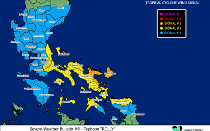
MANILA – Tropical cyclone wind signal (TCWS) No. 3 was hoisted over Catanduanes and more areas are expected to be placed under TCWS No. 3 in the next hours as Typhoon Rolly maintained its strength, a weather specialist said on Saturday.
As of 2 p.m., the weather bureau also hoisted TCWS No. 3 over the northeastern portion of Camarines Sur (Tinambac, Siruma, Goa, Tigaon, Sagnay, San Jose, Lagonoy, Garchitorena, Presentacion, Caramoan, Sagnay), and the northeastern portion of Albay (Tiwi, Malinao, Tabaco City, Malilipot, Santo Domingo, Bacacay, Rapu-Rapu).
“Rolly” was last seen 410 km. east-northeast of Virac, Catanduanes, moving west-southwestward at 15 kph.
It packs maximum sustained winds of 215 kph near the center and gustiness of up to 265 kph.
Ariel Rojas of the Philippine Atmospheric, Geophysical and Astronomical Services Administration (PAGASA) said Catanduanes and other areas placed under TCWS No. 3 must take the necessary precautions against the typhoon’s possible destructive effects, particularly on structures.
Destructive typhoon-force winds will be experienced in areas under TCWS No. 3.
Placed under TCWS No. 2 are the southeastern portion of Laguna (Santa Maria, Famy, Mabitac, Pakil, Siniloan, Pangil, Paete, Kalayaan, Lumban, Cavinti, Pagsanjan, Luisiana, Majayjay, Magdalena, Santa Cruz, Pila, Liliw, Nagcarlan, Rizal, Victoria, Calauan, San Pablo City, Alaminos, Bay), Quezon including Polillo Islands, Camarines Norte, the rest of Camarines Sur, the rest of Albay, Sorsogon, the northern portion of Masbate (Mobo, Milagros, Masbate City, Baleno, Aroroy, Mandaon, Balud) including Ticao and Burias Islands, Marinduque, Romblon, and Northern Samar.
Damaging gale to storm-force winds will be experienced in these areas.
TCWS No. 1, on the other hand, was hoisted over the rest of Masbate, Rizal, the rest of Laguna, Cavite, Batangas, Occidental Mindoro including Lubang Island, Oriental Mindoro, Metro Manila, Bulacan, Pampanga, Bataan, Zambales, Tarlac, Nueva Ecija, Aurora, Pangasinan, La Union, Benguet, Ifugao, Nueva Vizcaya, Quirino, and the southern portion of Isabela (Aurora, Luna, Reina Mercedes, Naguilian, Benito Soliven, San Mariano, Palanan, Dinapigue, San Guillermo, Echague, San Agustin, Jones, Cordon, Santiago City, Ramon, San Isidro, Angadanan, Alicia, Cauayan City, Cabatuan, San Mateo), the northern portion of Samar (Tagapul-An, Almagro, Santo Nino, Tarangnan, Catbalogan City, Calbayog City, Santa Margarita, Gandara, Pagsanghan, San Jorge, Jiabong, Motiong, Paranas, San Jose de Buan, Matuguinao), the northern portion of Eastern Samar (Taft, Can-Avid, Dolores, Maslog, Jipapad, Arteche, Oras, San Policarpo), and Biliran.
Strong breeze to near gale conditions would be likely in these areas.
Rojas noted a 36-hour lead time before strong winds can be felt in areas under TCWS No. 1.
Even if it is currently sunny in Metro Manila, the weather disturbance may be felt in the next hours, he said.
The northeasterly will cause strong breeze to near-gale conditions over Batanes, Babuyan Islands, Ilocos Norte, Apayao, and the coastal and mountainous areas of Cagayan and Isabela.
“Rolly” is forecast to remain a typhoon and may likely weaken as it emerges over the West Philippine Sea.
Based on PAGASA's forecast track, the eye of the typhoon is forecast to pass over Catanduanes and the mainland Camarines provinces on Sunday, and over mainland Quezon by Sunday afternoon.
Violent winds and intense rainfall associated with the inner rainband-eyewall region will be experienced over Catanduanes and the Camarines provinces early Sunday through the afternoon, and over Quezon and the southern portion of Aurora on Sunday.
After crossing the Southern Luzon - Metro Manila area, “Rolly” is forecast to exit the mainland Luzon landmass on Monday morning.
Regardless of where it would make landfall, Rojas said these areas, including Metro Manila, must prepare for strong winds and rainfall while “Rolly” traverses Luzon.
PAGASA expects “Rolly” to bring light to moderate with at times heavy rains over Bicol and Eastern Visayas.
On Sunday, heavy to intense rains will prevail over Metro Manila, Bicol, Calabarzon, Central Luzon, Marinduque, and the northern portions Occidental Mindoro and Oriental Mindoro.
Moderate to heavy rains will be experienced over the Cagayan Valley, Cordillera, and Ilocos regions, Romblon, and the rest of Occidental Mindoro and Oriental Mindoro.
Rough to phenomenal seas will prevail over the seaboards of areas where TCWS were hoisted.
Rough to very rough seas will be experienced over the remaining seaboards of Northern Luzon, and the eastern seaboards of Eastern Visayas (that are not under TCWS) and Caraga.
Sea travel is risky for all types of sea craft over these waters, especially those under TCWS, according to PAGASA.
Moderate to rough seas are likely over the remaining seaboards of the country.
PAGASA continues to monitor Tropical Depression Atsani outside the Philippine area of responsibility (PAR).
Rojas said it could enter PAR on Sunday but would unlikely affect the weather in the next two to three days. (PNA)
