Courtesy of PAGASA
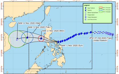
MANILA – Super Typhoon Rolly (international name: Goni) made second landfall over Tiwi, Albay, according to the 8 a.m. weather bulletin of the Philippine Atmospheric, Geophysical and Astronomical Services Administration (PAGASA) on Sunday.
The PAGASA earlier reported that “Rolly” has made first landfall in Bato, Catanduanes around 4:50 a.m. Sunday.
Based on its latest weather bulletin, the weather bureau said catastrophic violent winds and intense to torrential rainfall is expected within the next 12 hours over Catanduanes, Camarines Norte, Camarines Sur, Albay, the northern portion of Sorsogon, Burias Island, Marinduque, the central and southern portions of Quezon, Laguna, and the eastern portion of Batangas.
"The center of this typhoon will cross the Camarines provinces before heading towards Marinduque-southern Quezon area this afternoon,” PAGASA said.
“Rolly” is forecast to exit the mainland Luzon landmass and emerge over the West Philippine Sea between Sunday night and Monday early morning,” it added.
During its traverse of Southern Luzon, PAGASA said “Rolly” is forecast to weaken but will emerge as a typhoon over the West Philippine Sea.
Heavy to intense with at times torrential rains is expected over Bicol Region, Calabarzon, Metro Manila, Marinduque, Romblon, Mindoro Provinces, Bataan, Bulacan, Aurora, Northern Samar, Samar, Eastern Samar, Biliran, and the eastern portions of mainland Cagayan and Isabela.
Meanwhile, moderate to heavy rains with at times intense rains will be experienced over Cordillera Administrative Region, Leyte, and the rest of mainland Cagayan Valley and Central Luzon. Light to moderate with at times heavy rains will be experienced over Caraga, Northern Mindanao, Zamboanga Peninsula, and the rest of Luzon and Visayas.
The weather bureau warned the public against flash floods, rain-induced landslides, and sediment-laden streamflows (i.e. lahar) may occur during heavy or prolonged rainfall especially in areas that are highly or very highly susceptible to these hazards.
PAGASA said very destructive to devastating typhoon-force winds will be experienced in areas under Tropical Cyclone Wind Signal (TCWS) Nos. 4 and 5, destructive typhoon-force winds in areas under TCWS No. 3, damaging gale- to storm-force winds in areas under TCWS No. 2, and strong breeze to near gale conditions in areas under TCWS No. 1.
"In the next 24 hours, there is a high risk of storm surge of more than 3.0 meters over the coastal areas of Catanduanes and Camarines Norte and the northern coastal areas of Quezon including Polillo Islands and Camarines Sur; up to 3.0 meters over the coastal areas of Metro Manila, Cavite, Bulacan, Pampanga, Bataan, the southeastern coastal area of Batangas (facing Tayabas Bay), and most of the southern coastal areas of Quezon; up to 2.0 meters over the coastal areas of Marinduque, Lubang Island, Albay, Masbate (including Ticao and Burias Islands), Northern Samar, and Eastern Samar and the remaining coastal areas of Quezon, Camarines Sur, and Batangas," PAGASA said.
TCWS No. 5 is still up in Albay and Camarines Sur.
TCWS No. 4 is hoisted in:
-- Catanduanes, Camarines Norte
-- Northern portion of Sorsogon (Donsol, Pilar, Castilla, Sorsogon City, Prieto Diaz, Gubat, Barcelona, Juban, Casiguran, Magallanes)
-- Burias Island
-- Central and southern portions of Quezon (Real, Mauban, Perez, Alabat, Quezon, Calauag, Tagkawayan, Guinayangan, San Antonio, Tiaong, Dolores, Candelaria, Sariaya, Tayabas City, Sampaloc, Lucban, Lucena City, Pagbilao, Atimonan, Padre Burgos, Agdangan, Unisan, Plaridel, Gumaca, Lopez, Buenavista, San Narciso, San Andres, San Francisco, Mulanay, Catanauan, General Luna, Macalelon, Pitogo)
-- Central and southern portions of Rizal (Tanay, Antipolo City, San Mateo, Cainta, Taytay, Binangonan, Teresa, Morong, Cardona, Baras, Jala-Jala, Pililla, Angono),
-- Batangas
-- Cavite
-- Metro Manila
-- Laguna
-- Marinduque
-- Northern portion of Romblon (Concepcion, Corcuera, Banton)
-- Northern portion of Occidental Mindoro (Abra de Ilog)
-- Northern portion of Oriental Mindoro (Puerto Galera, San Teodoro, Baco, Calapan City, Naujan, Pola, Victoria, Socorro, Pinamalayan).
Areas under TCWS No. 3 are:
-- Rest of Sorsogon
-- Northern portion of Masbate (Mobo, Masbate City, Milagros, Uson, Baleno, Aroroy, Mandaon) including Ticao Island
-- Rest of Quezon including Polillo Island
-- Rest of Rizal, Bulacan, Pampanga, Bataan
-- Southern portion of Zambales (San Marcelino, San Felipe, Olongapo City, Subic, Castillejos, San Antonio, San Narciso, Botolan, Cabangan)
-- Central portion of Romblon (Calatrava, San Andres, San Agustin, Romblon, Magdiwang, San Fernando, Cajidiocan)
-- Central portion of Occidental Mindoro (Sablayan, Mamburao, Santa Cruz, Paluan) including Lubang Island
-- Central portion of Oriental Mindoro (Gloria, Bansud, Bongabong)
-- Northern Samar
TCWS No. 2 is up in Aurora, Nueva Vizcaya, Quirino, Benguet, La Union, Pangasinan, the rest of Zambales, Tarlac, Nueva Ecija, the rest of Oriental Mindoro, the rest of Occidental Mindoro, the rest of Romblon, the rest of Masbate, northern portion of Samar (Catbalogan City, Jiabong, Motiong, Paranas, Hinabangan, San Sebastian, Tarangnan, Pagsanghan, San Jorge, San Jose de Buan, Matuguinao, Gandara, Santa Margarita, Calbayog City, Santo Nino, Almagro, Tagapul-An), northern portion of Eastern Samar (San Julian, Sulat, Taft, Can-Avid, Dolores, Maslog, Oras, San Policarpo, Arteche, Jipapad), extreme northern portion of Antique (Pandan, Libertad, Caluya), and the northwestern portion of Aklan (Buruanga, Malay, Nabas, Ibajay).
On the other hand, TCWS No. 1 is hoisted in Mainland Cagayan, Isabela, Apayao, Kalinga, Mountain Province, Ifugao, Abra, Ilocos Norte, Ilocos Sur, Calamian Islands, rest of the northern portion of Antique (Sebaste, Culasi, Tibiao, Barbaza, Laua-An), the rest of Aklan, Capiz, the northern portion of Iloilo (Lemery, Sara, Concepcion, San Dionisio, Batad, Estancia, Balasan, Carles), northern portion of Cebu (San Remigio, Bogo City, Medellin, Daanbantayan) including Bantayan Islands, Biliran; rest of Samar, rest of Eastern Samar, and the northern portion of Leyte (San Isidro, Tabango, Villaba, Matag-Ob, Palompon, Ormoc City, Pastrana, Palo, Calubian, Leyte, Kananga, Capoocan, Carigara, Jaro, Tunga, Barugo, Alangalang, Santa Fe, Tacloban City, Babatngon, San Miguel).
Meanwhile, PAGASA reported the center of Tropical Storm Atsani (international name) was estimated at 1,205 km east of Southern Luzon at 7 a.m. Sunday.
“Atsani”, which will be given the domestic name “Siony”, currently has maximum sustained winds of 65 kph near the center and gustiness of up to 80 kph, it said.
“It remains less likely to affect any portion of the country over the next two to three days. It is likely to intensify into a severe tropical storm in the next 24 to 36 hours," PAGASA said. (PNA)
