(Image grabbed from PAGASA's Facebook page)
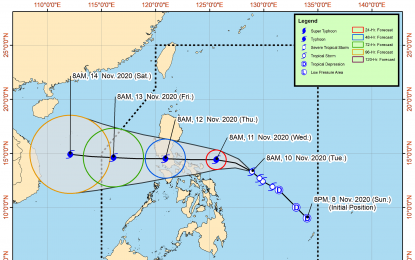
MANILA – Tropical Storm (TS) Ulysses slightly intensified and accelerated as it continues to bring strong winds in some parts of the Bicol Region, the weather bureau said on Tuesday.
In its 11 a.m. bulletin, the Philippine Atmospheric, Geophysical and Astronomical Services Administration (PAGASA) said "Ulysses" now packs a maximum sustained winds of 75 kilometers per hour (kph) near the center and gustiness of up to 90 kph.
The TS was last tracked 475 km east of Virac, Catanduanes, moving northwestward at 15 kph.
PAGASA weather specialist Ariel Rojas said Metro Manila and Calabarzon may also experience strong winds and rains in the next hours.
"Ulysses is more likely to make a close approach to Catanduanes and Camarines Sur on Wednesday, and may make landfall over Quezon on Thursday," he added.
It is forecast to exit the Philippine Area of Responsibility (PAR) on Friday afternoon, according to Rojas.
Meanwhile, Tropical Cyclone Wind Signal (TCWS) No. 1 remains hoisted over Catanduanes, Camarines Norte, Camarines Sur, Albay, Sorsogon, the eastern portion of Masbate (Aroroy, Pio V. Corpuz, Cataingan, Palanas, Uson, Dimasalang, Masbate City, Mobo, Baleno) including Ticao and Burias Islands, and the southern portion of Quezon (Atimonan, Padre Burgos, Agdangan, Unisan, Plaridel, Gumaca, Pitogo, Macalelon, General Luna, Lopez, Catanauan, Mulanay, San Francisco, San Andres, San Narciso, Buenavista, Guinayangan, Tagkawayan, Calauag, Quezon, Alabat, and Perez).
Northern Samar, the northern portion of Samar (Sto. Niño, Almagro, Tagapul-An, Tarangnan, Calbayog City, Santa Margarita, Gandara, Pagsanghan, San Jorge, San Jose de Buan, Matuguinao), and the northern portion of Eastern Samar (Maslog, Dolores, Oras, San Policarpo, Arteche, Jipapad) are also under Signal No. 1.
The TS will cause light to moderate with at times heavy rains over Aurora, Quezon, Bicol Region, eastern and central Visayas, Caraga, Zamboanga Peninsula, Basilan, Sulu, Tawi-Tawi.
The tail-end of a cold front will continue to cause light to moderate with at times heavy rains over Cagayan, including Babuyan Islands, Isabela, and Apayao.
Flooding, rain-induced landslides, and sediment-laden streamflows may occur during heavy or prolonged rainfall.
Rough to very rough seas will be experienced over the seaboards of areas under TCWS, and the eastern seaboard of Eastern Samar (that are not under TCWS) due to "Ulysses". Sea travel is risky over these waters, especially for mariners of small seacraft.
Moderate to rough seas will continue over the western seaboards of central and southern Luzon, and the eastern seaboard of Mindanao.
PAGASA advised mariners of small seacraft to take precautionary measures when venturing to the sea. (PNA)
