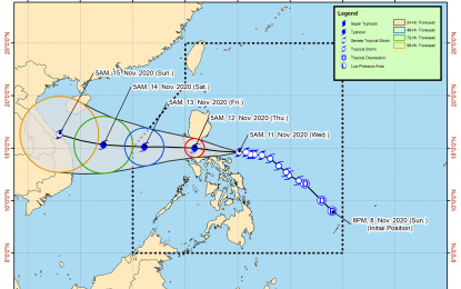
Track of "Ulysses" (Image grabbed from PAGASA's Facebook page)
MANILA – Severe Tropical Storm Ulysses has further intensified and is nearing the typhoon category, the weather bureau said on Wednesday.
In its 8 a.m. bulletin, the Philippine Atmospheric, Geophysical and Astronomical Services Administration (PAGASA) said "Ulysses" now packs maximum sustained winds of 110 kph and gustiness of up to 135 kph.
It was last seen at 135 km. north-northeast of Virac, Catanduanes or 350 km. east of Infanta, Quezon.
Tropical Cyclone Wind Signal (TCWS) No. 2 was hoisted over the central and southern portions of Quirino (Maddela, Cabarroguis, Aglipay, Nagtipunan), the central and southern portions of Nueva Vizcaya (Kasibu, Bambang, Kayapa, Dupax del Norte, Dupax del Sur, Aritao, Santa Fe, Alfonso Castaneda), the southern portion of Benguet (Bokod, Itogon, Tublay, La Trinidad, Sablan, Baguio City, Tuba), the southern portion of La Union (Burgos, Naguilian, Bauang, Caba, Aringay, Tubao, Pugo, Santo Tomas, Rosario, Agoo), Pangasinan, Zambales, Bataan, Tarlac, Pampanga, Nueva Ecija, Aurora, Bulacan, Metro Manila, Rizal, Laguna, Cavite, Batangas, Quezon including Polillo Islands, Marinduque, the northern portion of Occidental Mindoro (Paluan, Abra de Ilog) including Lubang Island, the northern portion of Oriental Mindoro (Pola, Victoria, Naujan, Baco, Calapan City, San Teodoro, Puerto Galera), Camarines Norte, Camarines Sur, Albay, Sorsogon, Catanduanes, and Burias and Ticao Islands.
Damaging gale force to storm force winds will prevail in these areas.
TCWS No. 1 was hoisted over Isabela, the rest of Quirino, the rest of Nueva Vizcaya, Kalinga, Mountain Province, Ifugao, the rest of Benguet, Abra, Ilocos Sur, the rest of La Union, the rest of Occidental Mindoro, the rest of Oriental Mindoro, Romblon, the rest of Masbate, northern Samar, the northern portion of Samar (Santo Nino, Almagro, Tagapul-An, Tarangnan, Calbayog City, Santa Margarita, Gandara, Pagsanghan, San Jorge, San Jose de Buan, Matuguinao), and the northern portion of Eastern Samar (Maslog, Dolores, Oras, San Policarpo, Arteche, Jipapad).
These areas will have strong breeze to near gale conditions.
The rest of northern Luzon will also experience strong breeze to gale force winds due to the surge of the northeast monsoon.
Meanwhile, heavy to intense with at times torrential rains will prevail over Camarines Norte, Camarines Sur, and Catanduanes.
Moderate to heavy with at times intense rains is expected over Albay, Sorsogon, Quezon, including Polillo Islands, and Burias and Ticao Islands.
Light to moderate with at times heavy rains will be experienced over Metro Manila and the rest of Luzon and the Visayas.
Flooding, rain-induced landslides, and sediment-laden stream flows may occur during heavy or prolonged rainfall, according to PAGASA.
Rough to very high seas will continue over the seaboards of areas under TCWS, and the eastern seaboard of Eastern Samar currently not under TCWS No. 1.
Rough to high seas will also prevail over the remaining seaboards of northern Luzon, and rough seas over the seaboards of Kalayaan Islands due to the surge of the northeast monsoon.
Sea travel is risky for all types of sea craft over these waters.
Moderate to rough seas will be experienced over the western seaboards of Palawan, including the Calamian Islands, and the eastern seaboards of Mindanao.
PAGASA advised mariners of small sea craft to take precautionary measures when venturing out to sea. (PNA)
