(Image grabbed from PAGASA website)
MANILA – Typhoon Ulysses has weakened and about to leave the Luzon landmass but still battering many areas with strong winds and rains, the weather bureau said on Thursday.
Heavy to intense, with at times torrential rains, however, continue over Metro Manila, Calabarzon, and Central Luzon and will likely persist until Thursday afternoon.
Moderate to heavy, with at times intense rains will be experienced over the Cordillera Administrative Region (CAR), mainland Cagayan Valley, Babuyan Islands, Pangasinan, Marinduque, and the northern portion of Mindoro provinces including Lubang Island.
Light to moderate with at times heavy rains will also be experienced over the Visayas and the rest of Luzon.
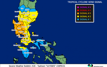
In its 8 a.m. bulletin, the Philippine Atmospheric, Geophysical and Astronomical Services Administration (PAGASA) said "Ulysses" was last spotted in the vicinity of Cabangan, Zambales, moving west-northwestward at 30 kph.
The typhoon now packs maximum sustained winds of 130 kph near the center and gustiness of up to 215 kph.
Tropical cyclone wind signal (TCWS) no. 3 was hoisted over the northern portion of Cavite (Naic, Tanza, Ternate, Maragondon, Rosario, Noveleta, Cavite City, Kawit, Bacoor, Imus, General Trias, Trece Martires City, Dasmariñas), Metro Manila, the western portion of Bulacan (San Miguel, San Ildefonso, San Rafael, Angat, Santa Maria, Marilao, Meycauayan City, Obando, Bulacan, Bocaue, Pandi, Bustos, Baliuag, Plaridel, Balagtas, Guiguinto, Malolos City, Paombong, Hagonoy, Calumpit, Pulilan), the western portion of Nueva Ecija (Gapan City, Peñaranda, Santa Rosa, Cabanatuan City, General Mamerto Natividad, Llanera, San Jose City, Lupao, Cabiao, San Isidro, San Leonardo, Jaen, San Antonio, Zaragoza, Aliaga, Talavera, Licab, Quezon, Santo Domingo, Guimba, Muñoz City, Talugtug, Cuyapo, Nampicuan), Pampanga, Tarlac, Bataan, Zambales, and Pangasinan. Destructive typhoon force winds will be experienced in these areas.
Areas under TCWS no. 2 are: central and southern portions of Isabela (Mallig, Quirino, Ilagan, Roxas, Burgos, Gamu, Palanan, San Mariano, Dinapigue, San Guillermo, Benito Soliven, Naguilian, Reina Mercedes, Luna, San Manuel, Aurora, Cabatuan, Cauayan City, San Mateo, Alicia, Angadanan, Echague, Jones, San Agustin, San Isidro, Ramon, Santiago City, Cordon), Quirino, Nueva Vizcaya, Mountain Province, Ifugao, Benguet, the southern portion of Ilocos Sur (Cervantes, Quirino, San Emilio, Lidlidda, Santiago, Banayoyo, Candon City, Galimuyod, Gregorio Del Pilar, Salcedo, Santa Lucia, Santa Cruz, Sigay, Suyo, Tagudin, Alilem, Sugpon), La Union, Aurora, the rest of Nueva Ecija, the rest of Bulacan, the northern and central portion of Quezon (San Antonio, Tiaong, Dolores, Candelaria, Sariaya, Lucban, Tayabas City, Lucena City, Pagbilao, Perez, Alabat, Atimonan, Padre Burgos, Agdangan, Plaridel, Mauban, Sampaloc, Real, General Nakar, Infanta) including Polillo Islands, Rizal, Laguna, the rest of Cavite, Batangas, the northern portion of Oriental Mindoro (Puerto Galera, San Teodoro, Baco, Calapan City), and the northern portion of Occidental Mindoro (Paluan, Abra de Ilog) including Lubang Island. Damaging gale to storm-force winds will prevail in these areas.
TCWS no. 1 was hoisted over the rest of Isabela, Kalinga, Abra, the rest of Ilocos Sur, the rest of Occidental Mindoro, the rest of Oriental Mindoro, Marinduque, the northern portion of Romblon (Corcuera, Banton, Concepcion), the rest of Quezon, Camarines Norte, and the western portion of Camarines Sur (Siruma, Tinambac, Calabanga, Bombon, Magarao, Canaman, Camaligan, Gainza, Pamplona, Pasacao, Libmanan, Cabusao, Sipocot, Lupi, Ragay, Del Gallego). These areas will experience strong breeze to near gale conditions.
Meanwhile, rough to very high seas will prevail over the seaboards of areas under TCWS and the northern seaboard of northern Samar.
Rough to high seas will continue over the remaining seaboards of northern Luzon, and rough to very rough seas over the western seaboard of Palawan including Calamian and Kalayaan Islands and the seaboards of Romblon and Bicol Region not under TCWS.
Sea travel is risky for all types of vessels over these waters.
Moderate to rough seas will be experienced over the eastern seaboards of Visayas and Mindanao, the seaboards of Cuyo Islands, and the western seaboard of Panay Island.
PAGASA advised mariners of small seacraft to take precautionary measures when venturing to the sea. (PNA)
