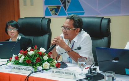
STAY ALERT. PAGASA Director Vicente Malano in an undated photo. In an interview on Friday (Nov. 13, 2020), Malano said this month’s weather condition is similar to what happened in November 2004 when typhoons hit the country one after the other. Seeing a pattern, he asked the public to stay alert at this time to reduce, if not avoid, loss of lives and damage to property. (Photo from DOST-PAGASA)
MANILA – Adequate reports were released to inform the public about the onslaught of incoming typhoons, a weather bureau official said Friday.
Philippine Atmospheric, Geophysical and Astronomical Services Administration (PAGASA) Director Vicente Malano, in an interview with the Philippine News Agency (PNA), said they have issued advisories on Typhoon Ulysses as soon as it developed into a tropical depression from just being a low-pressure area, as mentioned on their first bulletin published on Sunday evening.
“On the part of the Office of Civil Defense/Disaster Risk Reduction (and) Management Council, they provided enough warnings to would-be affected areas based on PAGASA's forecast, saying that 'Ulysses' would bring intense rains that can cause floods and gusty winds that can cause storm surges 2 (meters) to 3 meters and that those residing in low-lying areas and coastal areas should evacuate,” he said.
In its severe weather bulletin on Wednesday, PAGASA raised Tropical Cyclone Wind Signal (TCWS) Signal No. 3, where winds of 121 kph up to 170 kph may be expected in some parts of Luzon in at least 18 hours.
This came as “Ulysses” intensified into a typhoon at 8 a.m. on the same day.
Malano said PAGASA conducted a press briefing to alert the public.
Text alerts from the National Disaster Risk Reduction and Management Council (NDRRMC) were also disseminated to boost public awareness.
He noted that their forecasts are coordinated with the NDRRMC, the lead office during emergencies and calamities.
“The NDRRMC took our forecast and relayed it to their regional and municipal counterparts who then assisted the local government units (LGUs) for their preemptive response operations,” Malano said.
The would-be affected LGUs, on the other hand, have been advised to evacuate vulnerable residents, he said.
Trouble with evacuation
Marikina City was among the areas most devastated by the typhoon after its river overflowed at dawn on Thursday.
"Nakakatakot dahil parang ‘Ondoy’ ang karanasan namin dito. Dahil 'yung ‘Ondoy’, ganito rin nangyari. Habang natutulog ang lahat, biglang tumaas ang ilog (It was scary because what we experienced was like ‘Ondoy’, wherein the river overflowed while everyone was asleep)," Marikina City Mayor Marcelino Teodoro said, recounting his experience in an interview with DZBB.
Teodoro said evacuation efforts became complicated during the typhoon's onslaught from late Wednesday until early Thursday after power supply was cut off in some areas.
“The height of the flood exceeds the first floor of a house. We haven’t experienced this kind of flooding for so many months or years. That’s why everyone was surprised,” he said.
Teodoro sought national government assistance for air rescue as local officials and residents were “overwhelmed” by the floods.
He acknowledged certain lapses in the city’s preparations for “Ulysses” as they did not expect the Marikina River to swell up to 22 meters as of 11 a.m. on Thursday as he asked for back-up from the national government and private sectors.
The Philippine Coast Guard, Philippine National Police, Armed Forces of the Philippines, Bureau of Fire Protection, and other auxiliary groups were on standby and pushed for the rescue operations.
Government operations were ongoing as of writing.
Prepare for possible recurrence
Meanwhile, Malano said the same incident wherein typhoons developed one after the other occurred in 2004.
"Magkakamukha na magsunod-sunod ang bagyo weekly, four typhoons in November of 2004. Ngayon naman, November ulit, naka-tatlong bagyo na (The same happened in November 2004 when four typhoons developed successively. This month, we’ve already had three)," he said.
The strongest typhoon to hit land this year, Super Typhoon Rolly, which entered the Philippine area of responsibility as a severe tropical storm on October 29, was immediately followed by "Siony", "Tonyo", and "Ulysses".
Malano reminded the public to practice preparedness as the rainy season in Metro Manila usually brings flood, considering its canals are clogged with garbage.
PAGASA's weather surveillance radar can monitor weather disturbances from 400 km. away, which, depending on their movement, could reach and devastate populated areas in days as they gain strength.
He, however, clarified that all forecasts from different warning agencies across the globe have limitations, “ranging from data collection, processing, and analyses and even information." (PNA)
