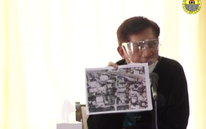
FLOOD PREVENTION. DENR Secretary Roy Cimatu shows a 1988 map of Cebu City which showed the blue line representing the downflow of a creek in Barangay Camputhaw. Cimatu on Monday (Nov. 16, 2020) pressed the Cebu City government to clear the creeks, rivers, estuaries and other waterways of structures that violated the three-meter easement as a measure to mitigate flooding during heavy downpour. (Screengrab from Cebu City Hall PIO video)
CEBU CITY – Department of Environment and Natural Resources (DENR) Secretary Roy Cimatu on Monday pressed the city government here to clear creeks and rivers of obstruction to prevent flash floods during heavy rains.
Cimatu made this call amid the heavy flooding brought by Typhoon Ulysses, saying that what happened in Northern Luzon may also happen here if the city government fails to address violations of the three-meter easements in creeks, rivers, estuaries and other waterways.
Cimatu presented a 1988 map of the city that showed a line of creeks, among them the one in Barangay Camputhaw that overflowed on Oct. 13 and caused flooding in the uptown vicinity.
“I was telling my DENR regional director here to cooperate with city government to implement the law. We just hope to clear all these creeks,” he said.
Cimatu said Mayor Edgardo Labella told him that a 16-year-old boy was swept by water during the heavy flooding on the night of Oct. 13.
The Cebu City Disaster Risk and Reduction Management Office retrieved the lifeless body of the boy beneath the structure that covered the Camptuhaw creek two days later.
“The map in the same area taken in 2011 already showed some structures (are already) covering the creek. I asked NAMRIA (National Mapping and Resource Information Authority) to trace the creek,” Cimatu said, recalling that a 2006 map also showed the area with no structures yet.
He called on the city to reestablish the three-meter easements in the waterways.
He said they will also implement the same measures to other localities in the country as a way of mitigating flooding incidents.
Labella, for his part, said the city will cooperate and comply with the directive of Cimatu.
The city met with owners of buildings that have impeded waterways here and implement the engineering solution by asking them to voluntarily demolish their structures to avoid court litigation. (PNA)
