(Image grabbed from PAGASA website)
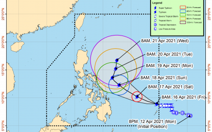
MANILA – The tropical cyclone that entered the Philippine Area of Responsibility (PAR) on Friday has intensified into a typhoon and was given the local name 'Bising', the weather bureau said in its 11 a.m. update.
'Bising' is currently not directly causing severe weather over any part of the country. It is also less likely to make landfall in any part of the country.
The Philippine Atmospheric, Geophysical and Astronomical Services Administration (PAGASA) expect the winds and heavy rains associated with 'Bising' will begin affecting portions of Eastern Visayas and Bicol Region starting Sunday.
The typhoon packs maximum sustained winds of 130 kph near the center, and gustiness of up to 160 kph. It was last seen 960 km. east of Surigao City, moving west northwestward at 15 kph.
PAGASA forecast "Bising" to bring rough to very rough seas over the eastern seaboards of the Visayas and Mindanao in the next 24 hours.
Mariners of small seacraft are advised to take precautionary measures when venturing out to the sea.
In anticipation of the onset of strong breeze to near gale conditions associated with the typhoon, tropical cyclone wind signal no. 1 may be raised over some localities in Northern Samar and Eastern Samar on Friday night, PAGASA said. (PNA)
