(Image courtesy of PAGASA)
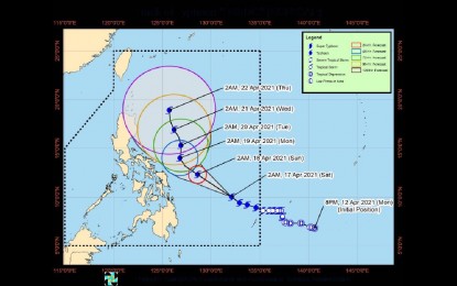
MANILA – Typhoon Bising has continued to strengthen and was last located at 705 km. east of Surigao City, Surigao del Norte.
In its severe weather bulletin issued at 5 a.m. Saturday, the Philippine Atmospheric, Geophysical and Astronomical Services Administration (PAGASA) said “Bising” continues to move west-northwest at 20 kph, packing maximum sustained winds of 175 kph near the center and gustiness of up to 215 kph.
Owing to favorable atmospheric and oceanic conditions, it said “Bising” has rapidly intensified and is expected to further strengthen and reach peak intensity at 195 kph to 205 kph on Sunday.
The typhoon is forecast to bring cloudy skies with scattered rain showers and thunderstorms over the Eastern Visayas, Caraga, and Davao regions.
Metro Manila and the rest of the country will have partly cloudy to cloudy skies with isolated rain showers brought by localized thunderstorms.
PAGASA said “Bising” will bring moderate to heavy with at times intense rains over Eastern Visayas, Sorsogon, Masbate, Albay, Camarines Sur, Catanduanes, and Camotes Islands on Sunday.
Tropical Cyclone Wind Signal (TCWS) No. 1 has been raised over the central and eastern portions of Sorsogon (Castilla, Magallanes, Matnog, Juban, Irosin, Bulan, Santa Magdalena, Bulusan, Barcelona, Casiguran, Gubat, Prieto Diaz, and Sorsogon City), the eastern portion of Albay (Manito, Legazpi City, Santo Domingo, Malilipot, Bacacay, Tabaco City, Rapu-Rapu, Malinaw, and Tiwi), the eastern portion of Camarines Sur (Presentacion, Caramoan, and Garchitorena), and Catanduanes in Luzon.
In the Visayas, TCWS No. 1 has been hoisted over Northern Samar, Samar, Eastern Samar, Biliran, Leyte, Southern Leyte, and Camotes Islands.
In Mindanao, the same TCWS has been raised over the Dinagat Islands, Surigao del Norte (including Siargao and Bucas Grande Islands), and Surigao del Sur.
Based on the current forecast scenario for the typhoon, PAGASA said TCWS No. 2 remains to be the highest level of wind signal that would be hoisted due to “Bising”.
“However, in the event of a further eastward or westward shift in the current track forecast, the highest level of wind signal that will be hoisted for this typhoon may be lower or higher than the current scenario suggests,” it added.
“Bising” will bring rough to very rough seas over the eastern seaboards of the Bicol, Eastern Visayas, Caraga, and Davao regions, with sea travel for all types of seacraft considered “risky” over these waters. (PNA)
