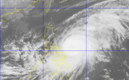
Courtesy of PAGASA/DOST
MANILA – Typhoon Bising slightly weakened and decelerated while moving west northwestward at 15 kilometer per hour (kph) over the Philippine Sea east of Catanduanes, the Philippine Atmospheric, Geophysical and Astronomical Services Administration (PAGASA) said on Sunday.
In its 5 p.m. severe weather bulletin, PAGASA said the eye of Typhoon Bising was located at 290 km east of Virac, Catanduanes with maximum sustained winds of 205 kph near the center and gustiness of up to 250 kph.
Moderate to heavy with at times intense rains will be experienced over Eastern Visayas and Bicol Region.
Tropical Cycling Wind Signal (TCWS) No. 2 remains hoisted over Catanduanes, Northern Samar, Eastern Samar, and Samar.
The weather bureau cautioned the residents in these areas of possible light to moderate damage to structures and vegetation due to strong winds and flash floods or landslides due to moderate to heavy rains.
On the other hand, areas under TWCS No. 1 are: eastern portion of Camarines Norte (San Lorenzo Ruiz, San Vicente, Vinzons, Talisay, Daet, Mercedes, and Basud), Camarines Sur, Albay, Sorsogon, Masbate including Burias and Ticao Islands, Biliran, Leyte, Southern Leyte, northern portion of Cebu (Tabogon, Borbon, San Remigio, Bogo City, Medellin, Daanbantayan) including Bantayan and Camotes Island, Dinagat Islands, Siargao Islands, and Bucas Grande Islands.
In the next 24 hours, rough to very high seas will be experienced over the northern and eastern seaboard of Eastern Visayas and rough to very rough seas over the eastern seaboard of Caraga.
“Sea travel is risky for all types of seacraft over these waters,” PAGASA said.
The typhoon is forecast to gradually weaken throughout the forecast period, PAGASA said. (PNA)
