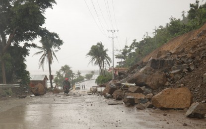
IMPASSABLE. The Virac-Bato Road portion is impassable on Monday (April 19,2021) due to a landslide. Clearing operation teams were immediately dispatched, according to Catanduanes Gov. Joseph Cua. (Photo courtesy of Catanduanes Provincial Office)
MANILA – Typhoon Bising (Surigae) has maintained its strength and continued to dump rains in the Bicol Region and some areas in the Visayas, the state weather bureau reported on Monday afternoon.
In its 5 p.m. bulletin, the Philippine Atmospheric, Geophysical and Astronomical Services Administration (PAGASA) said Bising is bringing moderate to heavy, with at times intense, rains over the Bicol Region, Northern Samar, Samar, Eastern Samar, Biliran, and the northern portion of Leyte.
The typhoon packs maximum sustained winds of 195 kilometer per hour (kph) near the center, and gustiness of up to 240 kph.
It was last seen 500 kilometers east of Infanta, Quezon, slowly moving north northwestward.
Tropical Cyclone Wind Signal (TCWS) No. 2 remained hoisted over Catanduanes, the eastern portion of Camarines Sur (Siruma, Tinambac, Lagonoy, Garchitorena, Caramoan, Goa, Tigaon, San Jose, Presentacion, Sagnay, Buhi), the eastern portion of Albay (Tiwi, Malinao, Tabaco City, Malilipot, Santo Domingo, Bacacay, Rapu-Rapu, Legazpi City, Manito), and the eastern and central portions of Sorsogon (Castilla, Sorsogon City, Prieto Diaz, Gubat, Barcelona, Casiguran, Juban, Magallanes, Bulan, Bulusan, Irosin, Santa Magdalena, Matnog), Northern Samar, the northern portion of Samar (Santo Nino, Almagro, Tagapul-An, Calbayog City, Santa Margarita, Gandara, Matuguinao, San Jose de Buan, San Jorge, Tarangnan, Pagsanghan, Catbalogan City, Paranas, Jiabong, Motiong, Hinabangan, San Sebastian), and the northern portion of Eastern Samar (San Julian, Sulat, Taft, Can-Avid, Dolores, Maslog, Oras, San Policarpo, Arteche, Jipapad).
TCWS No. 1 was hoisted over the eastern portion of Cagayan (Lal-Lo, Gattaran, Alcala, Baggao, Amulung, Solana, Iguig, Tuguegarao City, Enrile, Peñablanca, Camalaniugan, Aparri, Buguey, Santa Teresita, Gonzaga, Santa Ana), Isabela, Quirino, the northern and central portions of Aurora (Baler, Dipaculao, Dinalungan, Casiguran, Dilasag), the eastern portion of Quezon (Calauag, Guinayangan, Tagkawayan, Buenavista, San Narciso, San Andres) including Polillo Islands, Camarines Norte, the rest of Camarines Sur, the rest of Albay, the rest of Sorsogon, and Masbate including Burias and Ticao Islands, the rest of Samar, the rest of Eastern Samar, Biliran, Leyte, and the northern portion of Cebu (Tabogon, Borbon, San Remigio, Bogo City, Medellin, Daanbantayan) including Bantayan and Camotes Islands.
In the next 24 hours, the northeasterly wind flow enhanced by 'Bising' will also bring strong breeze to near gale conditions with higher gusts over most of northern Luzon, Aurora, and the rest of Quezon province that are not under TCWS.
Very rough to very high seas will be experienced over the eastern seaboard of Luzon, and rough to very high seas still prevail over the northern and eastern seaboards of Eastern Visayas. Sea travel is risky for all types of seacraft.
Rough to very rough seas remain over the northern and western seaboards of northern Luzon, and the eastern seaboard of Caraga.
Rough seas also continue over the remaining seaboards of localities where TCWS are in effect and the eastern seaboard of Davao Oriental. Sea travel is risky for small seacraft, PAGASA said.
Moderate to rough seas continue over the western seaboard of Central Luzon. PAGASA advised mariners of small seacraft not to venture out over these waters. (PNA)
