(Image grabbed from PAGASA's Facebook page)
MANILA – Typhoon Bising (international name Surigae) has further weakened as it continues to move slowly northward, the weather bureau said Tuesday.
Bising now packs maximum sustained winds of 175 kilometers per hour (kph) near the center and gustiness of up to 215 kph. It was last seen 505 kilometers east of Infanta, Quezon.
In its latest weather forecast, the Philippine Atmospheric, Geophysical and Astronomical Services Administration (PAGASA) said Catanduanes may still experience heavy to intense rains. Moderate to heavy rains will be experienced over the eastern portion of Camarines Sur and Rapu-Rapu Islands.
Flooding and rain-induced landslides are "highly likely to occur", especially in areas identified in hazard maps as highly susceptible to these events, PAGASA said.
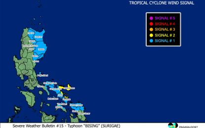
Tropical Cyclone Wind Signal (TCWS) No. 2 remains hoisted over Catanduanes, the eastern portion of Camarines Sur (Sagnay, San Jose, Lagonoy, Garchitorena, Presentacion, Caramoan), and the northeastern portion of Albay (Tiwi, Malinao, Tabaco City, Malilipot, Bacacay, Rapu-Rapu).
On the other hand, TCWS No. 1 is hoisted over Batanes, Cagayan including Babuyan Islands, Isabela, Quirino, Apayao, the eastern portion of Kalinga (Pinukpuk, Rizal, Tabuk City), the extreme eastern portion of Mountain Province (Paracelis), the extreme eastern portion of Ifugao (Alfonso Lista), the northern portion of Aurora (Baler, Dipaculao, Dinalungan, Casiguran, Dilasag), the eastern portion of Quezon (Calauag, Guinayangan, Tagkawayan, Buenavista, San Narciso, San Andres) including Polillo Islands, Camarines Norte, the rest of Camarines Sur, the rest of Albay, Sorsogon, and the northern portion of Masbate (Aroroy, Masbate City, Baleno, Mobo, Uson, Palanas, Dimasalang) including Burias and Ticao Islands, Northern Samar, the northern portion of Samar (Tagapul-An, Almagro, Santo Nino, Calbayog City, Santa Margarita, Gandara, Pagsanghan, Tarangnan, San Jorge, San Jose de Buan, Matuguinao), and the northern portion of Eastern Samar (Maslog, Can-Avid, Dolores, Oras, San Policarpo, Arteche, Jipapad).
The typhoon is expected to exit the Philippine Area of Responsibility on Sunday.
Bising and the enhanced northeasterly windflow will cause very rough to high seas over the northern and eastern seaboards of Luzon, and rough to high seas over the northern and eastern seaboards of Eastern Visayas. Sea travel is risky for all types of seacraft over these waters.
Rough seas are expected over the northern and western seaboards of Northern Luzon, the eastern seaboards of Caraga and Davao Oriental and the remaining seaboards of areas under TCWS. Sea travel is risky for small seacraft, PAGASA said.
Moderate to rough seas will be experienced over the western seaboard of Central Luzon. PAGASA advised mariners of small seacraft not to venture out over these waters. (PNA)
