(Image grabbed from PAGASA's Facebook page)
MANILA – Some areas in northern Luzon have been placed under tropical cyclone wind signals (TCWS) as Typhoon Bising maintained its strength as it moves over the Philippine Sea, the weather bureau said on Wednesday.
“Bising” was last spotted 395 km. east of Tuguegarao City, Cagayan, packing maximum sustained winds of 175 kph near the center and gustiness of up to 215 kph.
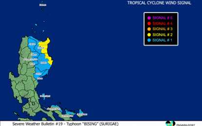
TCWS No. 2 remains hoisted over the eastern portion of Cagayan (Santa Ana, Gonzaga, Baggao, Gattaran, Lal-Lo, Peñablanca, Santa Teresita, Buguey) and the eastern portion of Isabela (Maconacon, Divilacan, Palanan).
These areas may expect winds greater than 61 kph and up to 120 kph in at least 24 hours, the Philippine Atmospheric, Geophysical and Astronomical Services Administration (PAGASA) said in its 5 a.m. bulletin.
On the other hand, TCWS No. 1 is still hoisted over Batanes, the rest of Cagayan, including the Babuyan Islands, the rest of Isabela, Quirino, Apayao, the eastern portion of Kalinga (Rizal, Tabuk City, Pinukpuk, Tanudan), the eastern portion of the Mountain Province (Paracelis, Natonin), the eastern portion of Ifugao (Alfonso Lista, Aguinaldo), the northern and central portion of Aurora (Dipaculao, Baler, Dinalungan, Casiguran, Dilasag), Polillo Islands, the northern portion of Camarines Norte (Capalonga, Jose Panganiban, Paracale, Vinzons, Talisay, Daet, Mercedes, Basud), the northeastern portion of Camarines Sur (Siruma, Tinambac, Lagonoy, Garchitorena, Caramoan), and the northern portion of Catanduanes (Caramoran, Viga, Gigmoto, Panganiban, Bagamanoc, Pandan).
Winds of 30 kph to 60 kph may be expected in at least 36 hours, or intermittent rains may be expected within 36 hours in areas under TCWS No. 1.
Rough to high seas will be experienced over the northern and eastern seaboards of Luzon. Sea travel is risky for all types of seacraft.
Rough to very rough seas may be expected over the western seaboards of northern Luzon, and the northern and eastern seaboards of northern Samar. Sea travel is risky for small seacrafts.
Moderate to rough seas will prevail over the western seaboard of Central Luzon, the remaining eastern seaboard of Eastern Visayas, and the eastern seaboard of Mindanao.
PAGASA advised mariners of small seacraft not to venture out over these waters. (PNA)
