(Image taken from PAGASA website)
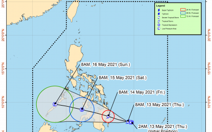
MANILA – Weather disturbance "Crising" has intensified into a tropical storm (TS) as it heads towards Davao Occidental and Surigao del Sur, the weather bureau said Thursday.
In its 11 a.m. bulletin, the Philippine Atmospheric, Geophysical and Astronomical Services Administration (PAGASA) said "Crising" now packs maximum sustained winds of 65 kilometers per hour (kph) near the center, and gustiness of up to 80 kph.
The TS was last seen 330 kilometers east of Davao City, moving west northwestward at 10 kph.
Tropical Cyclone Wind Signal (TCWS) No. 2 was hoisted over the southern portion of Surigao del Sur (Lingig, City of Bislig), the southeastern portion of Agusan del Sur (Trento, Santa Josefa), the northern portion of Davao Oriental (Boston, Cateel, Baganga), and the northeastern portion of Davao de Oro (Compostela, Montevista, Monkayo, New Bataan).
TCWS No. 1, on the other hand, was hoisted over the rest of Surigao del Sur, the rest of Agusan del Sur, the rest of Davao Oriental, the rest of Davao de Oro, Davao del Norte, Davao City, and the eastern portion of Bukidnon (Impasug-Ong, City of Malaybalay, Cabanglasan, San Fernando, Quezon, City of Valencia, Lantapan, Maramag, Dangcagan, Kitaotao, Don Carlos, Kibawe, Damulog).
Gale-force winds will be experienced in areas under TCWS No. 2, while strong breeze to near gale conditions will be experienced in localities where TCWS No. 1 was hoisted.
Moderate to heavy rains was forecast to prevail over Surigao del Sur, Agusan del Sur, Davao Oriental, Davao de Oro, and Davao del Norte.
Isolated to scattered flooding and rain-induced landslides are possible during heavy or prolonged rainfall.
Moderate to rough seas will be experienced over the eastern seaboard of Mindanao. PAGASA has advised mariners of small seacraft not to venture out over these waters. (PNA)
