(PAGASA image)
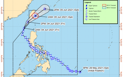
MANILA – Tropical Storm Dante (international name Choi-Wan) has left the Philippine Area of Responsibility (PAR) early Friday, a state forecaster said.
"It may re-enter PAR. The center of 'Dante' is expected to be 280 kilometers north of Itbayat, Batanes or over the coastal waters of Taitung County, Taiwan in the next 24 hours," Philippine Atmospheric, Geophysical and Astronomical Services Administration (PAGASA) weather specialist Shelly Ignacio said.
Dante packs maximum sustained winds of 65 km. per hour near the center and gustiness of up to 80 kph.
The weather bureau forecast “Dante” to cause scattered rain showers and thunderstorms over Ilocos Region, Zambales and Bataan.
“Dante” was last tracked 285 km. northwest of Laoag City, Ilocos Norte (outside PAR).
Metro Manila and the rest of the country may experience isolated rain showers due to localized thunderstorms.
Moderate to strong winds and moderate to rough seas will prevail over the northern and western sections of northern Luzon.
Elsewhere, winds will be light to moderate with slight to moderate seas.
Meanwhile, Ignacio said the low pressure area (LPA) inside the PAR was last seen 690 km. east of Legazpi City, Albay.
"It has a slim chance of developing into a tropical cyclone and may dissipate within 24 to 48 hours," Ignacio said. (PNA)
