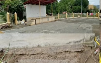
DAMAGED. The barangay plaza of Igmasandig in Valderrama, Antique plaza was damaged due to soil depression on June 11, 2021. The initial findings of Phivolcs Antique showed rain-induced landslide was the main cause of the phenomenon. (Photo courtesy of Antique PDRRMO)
SAN JOSE DE BUENAVISTA, Antique – Monsoon rains that poured over the province in the past days induced the landslide that caused the soil depression in Barangay Igmasandig in Valderrama, Antique, damaging the village's hall, houses, and other structures.
This was the initial result of the investigation of a team from the Philippine Institute of Volcanology and Seismology (Phivolcs) in Antique headed by Engineer Abraham Fabila on Sunday, Provincial Disaster Risk Reduction and Management (PDRRM) Officer Broderick Train said in an interview Monday.
“The Phivolcs Antique provincial personnel also interviewed some residents so that they could send the necessary data to their central office for its study and recommendations,” Train said.
He added that the initial investigation ruled out the notion that the soil depression was due to the 4.8 magnitude earthquake on June 7, where its epicenter was traced in Valderrama town.
The soil depression occurred in the village four days after the earthquake.
Train, however, said the final findings and recommendation will come from the Phivolcs central office based on facts and pieces of evidence gathered by the provincial office.
Train said the initial findings of the Phivolcs were similar to the result of the investigation that was conducted by the Western Visayas regional office of the Mines and Geosciences Bureau (MGB) on June 12.
“The MGB Regional Office 6 found the barangay to have ‘very high susceptibility to landslide,” Train said.
He added that the 2011-2013 geo-hazard mapping of the MGB found the village to have a moderate susceptibility to landslide.
The village has for its backdrop Mount Igcuron while fronting it is the Cangaranan River where the West Panay Fault is located.
The local government unit of Valderrama is also in the process of conducting damage and risk assessment in order to determine the number of families displaced and houses damaged.
Initial reports showed seven houses were totally damaged and nine incurred partial damage as per information from Valderrama Mayor Mary Joyce Roquero.
As of June 12, Roquero said 27 families are staying in the municipal evacuation center while 13 families are at the Valderrama Central School. (PNA)
