(File photo)
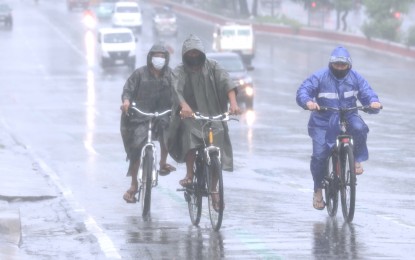
MANILA – The southwest monsoon (habagat) will continue to drench many areas in Luzon, the weather bureau said Wednesday.
The "habagat" is still being enhanced by Typhoon Fabian and the weather disturbance outside the Philippine Area of Responsibility with the international name "Cempaka", the Philippine Atmospheric, Geophysical and Astronomical Services Administration (PAGASA) said in its 5 a.m. weather bulletin.
Metro Manila, the Ilocos and Cordillera regions, Batanes, Babuyan Islands, Zambales, Bataan, Pampanga, Bulacan, Cavite, Batangas, Occidental Mindoro, and northern Palawan, including the Calamian Islands, will continue to experience monsoon rains.
"Fabian", which was last tracked 740 km. east-northeast of Itbayat, Batanes, is not expected to bring heavy rains across the country.
The typhoon packs maximum sustained winds of 130 kph near the center and gustiness of up to 160 kph.
No tropical cyclone wind signal is currently in effect.
Due to the enhanced "habagat", rough to very rough seas will be experienced over the seaboards of Batanes and the Babuyan Islands, and the western seaboard of Palawan (including the Kalayaan and Calamian Islands) and Occidental Mindoro (including Lubang Islands).
Moderate to rough seas will also prevail over the eastern and the rest of the northern and western seaboards of Luzon.
PAGASA said sea travel is risky for small seacraft, while mariners without the proper experience should immediately seek safe harbor.
Meanwhile, scattered rain showers and thunderstorms will prevail over Western Visayas and the rest of Luzon. Flash floods or landslides are possible during moderate to at times heavy rains.
The rest of the country will have rain showers or thunderstorms.
Light to moderate winds and slight to moderate seas are forecast over Mindanao, PAGASA said. (PNA)
