(Image grabbed from PAGASA's Facebook page)
MANILA – Tropical Depression (TD) Jolina slightly intensified, and tropical cyclone wind signal (TCWS) No. 1 has been hoisted over more areas, a weather forecaster said Monday noon.
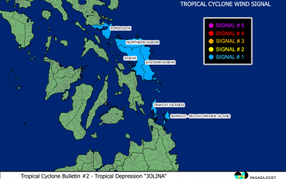
"Because 'Jolina' is near the landmass, TCWS No. 1 has been hoisted over Sorsogon, Northern Samar, Samar, Eastern Samar, Dinagat Islands, Siargao Islands, and Bucas Grande Islands," Philippine Atmospheric, Geophysical and Astronomical Services Administration (PAGASA) weather forecaster Chris Perez said.
He added that these areas will experience rains and strong winds.
"Jolina" packs maximum sustained winds of 55 kilometers per hour (kph) near the center, and gustiness of up to 70 kph. It was last tracked 205 km. east southeast of Guiuan, Eastern Samar, or 230 km. east northeast of Surigao City, Surigao del Norte.
PAGASA forecast moderate to heavy rains over Eastern Samar, Dinagat Islands, and Surigao del Norte including Siargao and Bucas Grande Islands.
Light to moderate, with at times heavy rains may also be experienced over northern Cebu, Bohol, Camiguin, and the rest of Eastern Visayas.
Isolated to scattered flash flooding and rain-induced landslides are possible, especially in areas susceptible to these hazards.
"We are expecting 'Jolina' to be in the vicinity of San Mariano, Isabela, by Thursday. 'Jolina' may make landfall over the Isabela area," Perez said, adding that "Jolina" will exit the Philippine Area of Responsibility on Friday.
The TD may intensify into a tropical storm prior to its landfall.
Meanwhile, Perez said moderate to rough seas will continue to prevail over the eastern seaboards of the Visayas and Mindanao.
PAGASA maintained that mariners of small seacraft should take precautionary measures when venturing out to the sea. (PNA)
