(Image grabbed from PAGASA's Facebook page)
MANILA – Some areas in Luzon and the Visayas have been placed under Tropical Cyclone Wind Signal (TCWS) No. 3 as Typhoon Jolina continues to move west-northwestward over the Samar Sea.
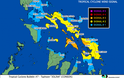
In its 8 a.m. weather bulletin on Tuesday, the Philippine Atmospheric, Geophysical and Astronomical Services Administration (PAGASA) said these areas are the northern and eastern portions of Masbate (Pio V. Corpuz, Palanas, Cataingan, Placer, Dimasalang, Uson, Cawayan, Esperanza, Mobo, Aroroy, Baleno, City of Masbate, Mandaon, Milagros), including Ticao and Burias Islands; the extreme western portion of Northern Samar (San Vicente, Capul, San Isidro, San Antonio), the northern portion of Biliran (Kawayan, Maripipi, Almeria), and the northwestern portion of Samar (Santo Niño, Tagapul-An, Almagro, Calbayog City).
Destructive typhoon-force winds may be experienced in these areas within 18 hours, PAGASA said.
The following areas have been placed under TCWS No. 2 -- Albay, Sorsogon, the rest of Masbate, the western and southern portions of Camarines Sur (Del Gallego, Lupi, Ragay, Libmanan, Sipocot, Cabusao, Pasacao, Pamplona, Gainza, Camaligan, Canaman, Magarao, Bombon, Naga City, Pili, Ocampo, Iriga City, Sagñay, Buhi, Milaor, San Fernando, Minalabac, Bula, Nabua, Baao, Balatan, Bato, Calabanga), the western portion of Camarines Norte (Capalonga, Jose Panganiban, Labo, San Vicente, San Lorenzo Ruiz, Santa Elena), Marinduque, the southern portion of Quezon (Tagkawayan, Guinayangan, Buenavista, Mulanay, San Narciso, San Francisco, San Andres, Catanauan, Calauag, General Luna, Lopez, Macalelon, Perez, Alabat, Quezon, Atimonan, Padre Burgos, Agdangan, Unisan, Pitogo, Gumaca, Plaridel), and the eastern portion of Romblon (San Fernando, Magdiwang, Cajidiocan, Romblon, Banton, Corcuera).
Also placed under Signal No. 2 are the rest of Biliran, the western portion of Northern Samar (Silvino Lobos, Lope de Vega, Catarman, Bobon, San Jose, Rosario, Lavezares, Biri, Allen, Victoria, Mondragon), the rest of Samar, and the northern portion of Leyte (Calubian, San Isidro, Tabango, Leyte, Villaba, Matag-Ob, Kananga, Carigara, Jaro, Pastrana, Santa Fe, Tacloban City, Barugo, San Miguel, Alangalang, Tunga, Babatngon, Capoocan).
Areas under Signal No. 2 may have gale-force to storm-force winds within 24 hours.
On the other hand, areas under Signal No. 1 are Catanduanes, the rest of Camarines Sur, the rest of Camarines Norte, the rest of Quezon including Polillo Islands, Laguna, Cavite, Batangas, Rizal, Metro Manila, Bulacan, the rest of Romblon, and Oriental Mindoro; the rest of Northern Samar, the rest of Eastern Samar, the rest of Leyte, the northern portion of Southern Leyte (Silago, Bontoc, Sogod), the northern portion of Cebu (Carmen, Tuburan, Catmon, Sogod, Tabuelan, Borbon, Tabogon, San Remigio, City of Bogo, Medellin, Daanbantayan) including Camotes and Bantayan Islands, the northeastern portion of Iloilo (Concepcion, Sara, San Dionisio, Batad, Estancia, Carles, Balasan), the northern portion of Aklan (Malay, Nabas, Ibajay, Tangalan, Makato, Numancia, Lezo, New Washington, Kalibo, Batan, Altavas) and the northern portion of Capiz (Pilar, Panay, Roxas City, Sapi-An, Ivisan, Pontevedra, Panitan, President Roxas, Ma-Ayon).
These areas may experience strong winds.
"Jolina" packs maximum sustained winds of 120 kilometers per hour (kph) near the center and gustiness of up to 150 kph.
Heavy to intense, with at times torrential rains will prevail over Northern Samar, Eastern Samar, Samar, Leyte, Biliran, Sorsogon, Albay, Romblon, and Masbate.
Moderate to heavy, with at times intense rains are also likely over the southern portion of Quezon, Occidental Mindoro, Oriental Mindoro, Marinduque, and the rest of Bicol Region and the Visayas.
PAGASA said scattered to widespread flooding and rain-induced landslides are possible, especially in areas susceptible to these hazards.
Rough to very rough seas will prevail over the seaboards of areas under TCWS No. 3 and 2. Sea travel is risky for all types of seacraft over these waters.
Moderate to rough seas is expected over the seaboards of areas under TCWS No. 1, the remaining seaboards of the Visayas, and the northern eastern seaboards of Mindanao.
PAGASA advised mariners of small seacrafts to take precautionary measures when venturing out to the sea. (PNA)
