(Image grabbed from PAGASA's website)
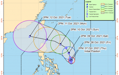
MANILA – Tropical Depression (TD) Maring will be slowly moving within 24 hours, and its trough will cause rains over Eastern Visayas, a weather forecaster said Thursday night.
The TD was last seen 505 kms. east of Virac, Catanduanes, moving south southeastward at 15 kph. It packs a maximum sustained winds of 45 kph near the center, and gustiness of up to 55 kph.
"It ("Maring") is a bit broad, and its trough is affecting Eastern Visayas," Ana Clauren of the Philippine Atmospheric, Geophysical and Astronomical Services Administration (PAGASA) said.
Light to moderate, with at times heavy rains will be experienced over the area. Floods and landslides are possible, especially in areas highly susceptible to these hazards.
No tropical cyclone wind signal was hoisted on any part of the country. However, it may cause moderate to rough seas over the seaboards of Luzon and the eastern and western seaboards of the Visayas and Mindanao.
These sea conditions are risky, especially for those using small seacraft.
"Maring" is forecast to remain as a TD, and develop into a tropical storm by Sunday.
Meanwhile, Clauren said PAGASA is also monitoring two weather disturbances outside the Philippine Area of Responsibility (PAR).
The first is a TD (formerly "Lannie") that was last tracked 770 kms. north northwest of Kalayaan Island, Palawan. It continues to move away from PAR, Clauren said.
The second is a low-pressure area (LPA) 1,610 kms. east of central Luzon. (PNA)
