(Courtesy of DOST-PAGASA)
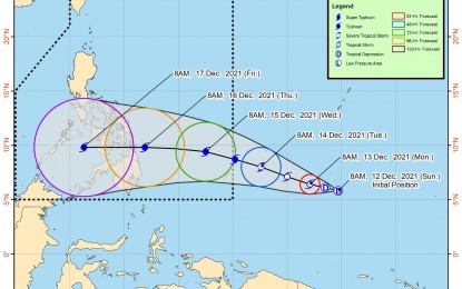
MANILA – A low pressure area (LPA) outside the Philippine Area of Responsibility (PAR) southeast of Palau has developed into tropical depression (TD), the Philippine Atmospheric, Geophysical and Astronomical Services Administration (PAGASA) said on Sunday.
In its latest weather bulletin, the weather bureau reported the center of the tropical depression was estimated at 2,095 kilometers east of Mindanao outside the PAR as of 10 a.m.
It has maximum sustained winds of 45 km per hour near the center with gustiness up to 55 kph with its present movement almost stationary, it said.
"The tropical depression is forecast to move generally west northwestward over the next three days and may enter the PAR on Tuesday," the PAGASA said. "Once inside the PAR, the domestic name “Odette” will be assigned to this tropical cyclone".
It added that the tropical cyclone will begin to move westward and may make landfall over Eastern Visayas-Caraga area by Wednesday evening or Thursday morning.
The tropical depression is forecast to gradually intensify and may reach tropical storm category within the next 24 hours.
Current track and intensity forecast show that there is a moderate to high likelihood that Tropical Cyclone Wind Signal (TCWS) will be hoisted for the provinces of Visayas and Mindanao.
The highest possible wind signal that may be hoisted for this tropical cyclone is TCWS #4.
PAGASA advised the public and disaster risk reduction and management offices to continue monitoring for updates related to this tropical cyclone considering these developments.
It will issue the next tropical cyclone advisory at 11 p.m. on Sunday. (PNA)
