(Image grabbed from PAGASA's Facebook page)
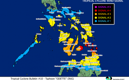
MANILA – Typhoon Odette has further intensified while threatening the Bucas Grande - Siargao Island and Dinagat Islands area, prompting the raising of Tropical Cyclone Wind Signal (TCWS) No. 4 in some areas.
In its 11 a.m. severe weather bulletin, the Philippine Atmospheric Geophysical and Astronomical Services Administration (PAGASA) said "Odette" now packs maximum sustained winds of 185 km. per hour (kph) near the center, and gustiness of up to 230 kph. It was last tracked 175 kilometers east of Surigao City, Surigao del Norte.
Very destructive typhoon-force winds may be experienced in areas where tropical cyclone wind signal (TCWS) No. 4 has been hoisted. These include Southern Leyte, and the eastern portion Bohol (Talibon, Trinidad, San Miguel, Dagohoy, Pilar, Sierra Bullones, Jagna, Garcia Hernandez, Duero, Guindulman, Anda, Candijay, Alicia, Mabini, Ubay, Pres. Carlos P. Garcia, Bien Unido), Dinagat Islands, Surigao del Norte including Siargao and Bucas Grande Islands.
Areas under TCWS No. 3 and where destructive typhoon-force winds will prevail are the southern portion of Leyte (Abuyog, Mahaplag, Hilongos, Bato, Matalom, Hindang, Inopacan, City of Baybay, Javier, Macarthur), the southern and central portions of Cebu (Camotes Islands, Tuburan, Catmon, Carmen, Danao City, Asturias, Balamban, Cebu City, Compostela, Liloan, Consolacion, Lapu-Lapu City, Mandaue City, Toledo City, City of Talisay, Minglanilla, Samboan, Sibonga, Alcoy, Ginatilan, Boljoon, City of Carcar, Malabuyoc, Moalboal, Cordova, Oslob, Aloguinsan, Pinamungahan, Barili, Santander, Badian, Dalaguete, Alcantara, Ronda, Alegria, City of Naga, Argao, San Fernando, Dumanjug, Sogod), the rest of Bohol, Negros Oriental, Siquijor, the southern and central portions of Negros Occidental (Calatrava, San Carlos City, Salvador Benedicto, City of Talisay, Silay City, Bacolod City, Murcia, Bago City, Valladolid, Pulupandan, La Carlota City, San Enrique, La Castellana, Moises Padilla, Pontevedra, Hinigaran, Isabela, Binalbagan, City of Himamaylan, City of Kabankalan, Ilog, Cauayan, Candoni, City of Sipalay, Hinoba-An), and Guimaras; northern portion of Agusan del Norte (Kitcharao, Jabonga, Santiago, Tubay, City of Cabadbaran), and the northern portion of Surigao del Sur (Carrascal, Cantilan, Madrid, Carmen, Lanuza, Cortes, City of Tandag).
Damaging gale to storm-force winds are expected under TCWS No. 2 in the southern portion Albay (city of Tabaco, Malilipot, Rapu-rapu, Bacacay, Santo Domingo, Legazpi City, Manito, Camalig, Daraga, Jovellar, Guinobatan, Pio Duran, City of Ligao, Oas), Sorsogon, Masbate including Ticao and Burias Islands, Romblon, the central and southern portions of Oriental Mindoro (Pinamalayan, Gloria, Bansud, Bongabong, Roxas, Mansalay, Bulalacao, Socorro, Pola), the central and southern portions of Occidental Mindoro (Sablayan, Calintaan, Rizal, San Jose, Magsaysay),and Palawan (El Nido, Calamian Islands, Taytay, Dumaran, Araceli, Cuyo Islands).
Also under TCWS No. 2 are Northern Samar, Eastern Samar, Samar, Biliran, the rest of Leyte, the rest of Cebu, the rest of Negros Occidental, Iloilo, Capiz, Aklan, and Antique, the rest of Surigao del Sur, Agusan del Sur, the rest of Agusan del Norte, the extreme northern portion of Zamboanga del Norte (Dapitan City, Siayan, Sindangan, Jose Dalman, Manukan, Pres. Manuel A. Roxas, Katipunan, Sergio Osmeña Sr., Polanco, Dipolog City, Piñan, Mutia, La Libertad, Rizal, Sibutad), the extreme northern portion of Zamboanga del Sur (Josefina, Molave, Mahayag, Dumingag, Tambulig), Misamis Occidental, the northern portion of Lanao del Norte (Kolambugan, Maigo, Munai, Bacolod, Poona Piagapo, Kauswagan, Pantao Ragat, Matungao, Linamon, Baloi, Tagoloan, Pantar, Iligan City), Misamis Oriental, Camiguin, the northern portion of Bukidnon (Cabanglasan, City of Malaybalay, Lantapan, Talakag, Baungon, Libona, Manolo Fortich, Sumilao, Impasug-Ong, Malitbog), and the northern portion of Lanao del Sur (Tagoloan II, Kapai).
Some areas in Luzon and Mindanao are under TCWS No. 1. These are Catanduanes, Camarines Norte, Camarines Sur, the rest of Albay, Marinduque, the southern portion of Quezon (San Antonio, Tiaong, Candelaria, Sariaya, Dolores, Lucena City, Pagbilao, Padre Burgos, Atimonan, Agdangan, Unisan, Gumaca, Plaridel, Pitogo, Lopez, Guinayangan, Buenavista, Catanauan, General Luna, Macalelon, Mulanay, San Narciso, San Andres, San Francisco, Tagkawayan, Calauag, Quezon, Alabat, City of Tayabas, Perez), Batangas, the rest of Oriental Mindoro, the rest of Occidental Mindoro, the rest of mainland Palawan including Balabac and Kalayaan Islands, northern portion of Davao Oriental (Baganga, Cateel, Boston), the northern portion of Davao de Oro (Laak, Mawab, Nabunturan, Montevista, Monkayo, New Bataan, Compostela), the northern portion of Davao del Norte (Talaingod, Santo Tomas, Kapalong, Asuncion, San Isidro, New Corella), the rest of Bukidnon, the rest of Lanao del Norte, the rest of Lanao del Sur, the rest of northern portion of Zamboanga del Norte (Labason, Kalawit, Tampilisan, Liloy, Salug, Godod, Bacungan, Gutalac, Baliguian), the rest of northern portion of Zamboanga del Sur (Bayog, Lakewood, Kumalarang, Guipos, Dumalinao, Tukuran, Ramon Magsaysay, Aurora, Sominot, Tigbao, Labangan, Pagadian City, Midsalip,), and the northern portion of Zamboanga Sibugay (Titay, Ipil, Naga, Kabasalan, Siay, Diplahan, Buug).
Strong winds with higher gusts are likely in those areas.
Moderate to very high seas will be experienced over the seaboards of areas where TCWS is in effect. Further, gale warning remains in effect for several coastal waters not under any wind signal, specifically the seaboard of northern Luzon, and eastern seaboards of central and southern Luzon.
PAGASA added that moderate to rough seas will still prevail over the remaining seaboards of the country that are not under any TCWS.
Meanwhile, heavy to torrential rains are forecast over Caraga, Central Visayas, Misamis Oriental, Camiguin, Southern Leyte, and Negros Occidental.
Moderate to heavy, with at times intense rains will prevail over Leyte, the southern portions of Eastern Samar and Samar, Zamboanga del Norte, Lanao del Sur, Davao Oriental, Davao de Oro, Davao del Norte, and the rest of Northern Mindanao.
On the other hand, light to moderate, with at times heavy rains may be experienced over Bicol Region, Quezon, and the rest of the Visayas, the rest of Zamboanga Peninsula, and mainland Bangsamoro.
"Odette" is expected to make its initial landfall in the vicinity of Siargao-Bucas Grande Islands or Dinagat Islands between 1 p.m. and 3 p.m. Thursday. (PNA)
