(Courtesy of PAGASA-DOST)
MANILA – More areas have been placed under Tropical cyclone wind signal (TCWS) No. 2 after Tropical Storm Agaton further intensified, the Philippine Atmospheric, Geophysical and Astronomical Services Administration (PAGASA) said on Sunday.
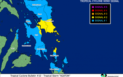
In its 8 a.m. bulletin, PAGASA said the center of “Agaton” was spotted over the coastal waters of Guiuan, Eastern Samar moving west northwestward at 10 kilometers per hour.
It has maximum sustained winds of 75 kph near the center and gustiness of up to 105 kph.
The weather bureau said the following areas were placed under TCWS No. 2:
*The southern portion of Eastern Samar (Guiuan, Mercedes, Salcedo, Quinapondan, Giporlos, Balangiga, Lawaan, General Macarthur, Hernani, Llorente, Balangkayan, Maydolong, Borongan City(sad)
*The southern portion of Samar (Marabut, Basey, Calbiga, Pinabacdao, Villareal, Santa Rita); and
*The northeastern portion of Leyte (Babatngon, Tacloban City, Palo, Tanauan, Tolosa)
Meanwhile, the rest of Eastern Samar; the rest of Samar, Northern Samar and Biliran; the rest of Leyte, Southern Leyte; and the rest of the northeastern portion of Cebu (Daanbantayan, Medellin, Bogo City, Tabogon, Borbon) including Camotes Islands are now under TCWS No. 1.
PAGASA said winds may reach gale-force in strengthen in any of the areas under TCWS No. 2 “throughout the passage” ‘Agaton.
“These conditions may be risky for most seacraft,” PAGASA warned.
It added that areas under TCWS No. 1, on the other hand, will experience strong winds that “maybe risky for hose using small seacraft.
“Agaton” is forecast to move erratically or remain almost stationary over the southern portion of Samar Islands and its coastal waters due to weak steering environment.
Heavy rainfall will be experienced over Eastern Visayas, Dinagat Islands, Surigao del Norte, Agusan del Norte, Bohol, Cebu, Masbate, Sorsogon, Albay, Catanduanes, Romblon, Northern Mindanao, and the rest of Visayas and Caraga in the next 24 hours, PAGASA said.
The weather bureau added that “Agaton” is also expected to degenerate into a remnant low by late Tuesday or early Wednesday as another tropical cyclone with the international name “Malakas” outside the Philippine Area of Responsibility (PAR) “begins to assimilate its circulation.”
According to PAGASA, “Malakas” maintains its strength while tracking northwestward with maximum sustained winds of 75 kph near the center and gustiness of up to 90 kph. Its center was estimated at 1,815 km East of Mindanao.
PAGASA added that “Malakas” may enter PAR by late Monday or early Tuesday but “is unlikely to directly affect the weather condition in the country” as it is expected to leave PAR region by late Tuesday or early Wednesday. (PNA)
