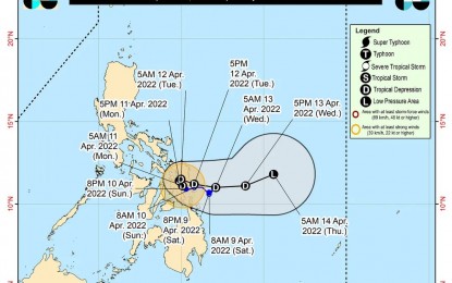
Track of Tropical Depression Agaton (Image from PAGASA's Facebook page)
MANILA – Weather disturbance "Agaton" (international name Megi) has weakened into a tropical depression and was last located over the coastal waters of Tanauan, Leyte, the weather bureau said in its 8 a.m. bulletin Monday.
"Agaton" now packs maximum sustained winds of 55 kph near the center, and gustiness of up to 75 kph. It is moving north northwestward slowly.
Tropical Cyclone Wind Signal (TCWS) No. 1 has been hoisted over the southern portion of Masbate (Dimasalang, Palanas, Cataingan, Pio V. Corpuz, Esperanza, Placer, Cawayan); Eastern Samar, Samar, Northern Samar, Biliran, Leyte, Southern Leyte, the northeastern portion of Cebu (Daanbantayan, San Remigio, Medellin, City of Bogo, Tabogon, Borbon, Sogod, Catmon, Carmen, Danao City, Compostela, Liloan) including Camotes Island, and the eastern portion of Bohol (Getafe, Talibon, Bien Unido, Trinidad, Ubay, San Miguel, Pres. Carlos P. Garcia, Mabini); Surigao del Norte and Dinagat Islands.
Strong breeze to near gale conditions will prevail in these areas, while rough to very rough seas are forecast over their seaboards.
The Philippine Atmospheric, Geophysical and Astronomical Services Administration (PAGASA) said these conditions may be risky for most sea vessels. Mariners of these vessels are advised to remain in port or take shelter, and those operating larger vessels are advised to take precautionary measures when venturing into the sea and, if possible, avoid navigating in these conditions.
Moderate to rough seas will also prevail over the remaining seaboards of the country that are not under any wind signal.
Moderate to heavy, with at times intense rains will be experienced over Eastern Visayas, Masbate, Sorsogon, Catanduanes, and the northern and central portions of Cebu including Bantayan and Camotes Islands.
Light to moderate, with at times heavy rains are likely over Dinagat Islands, Oriental Mindoro, Marinduque, Romblon, Quezon, and the rest of Bicol Region and the Visayas.
PAGASA said "Agaton" may further weaken by Wednesday.
Meanwhile, Tropical Storm Malakas is forecast to enter the Philippine Area of Responsibility (PAR) on Tuesday.
PAGASA said "Malakas" is unlikely to directly affect the weather condition in the country and is likely to exit PAR either Tuesday or Wednesday.
201 barangays affected
In its Monday morning update, the National Disaster Risk Reduction and Management Council said "Agaton" has so far affected 201 barangays in eight regions in the country.
Theses areas are Regions 6, 7, 8, 10, 11, 12, Caraga and the Bangsamoro Autonomous Region in Muslim Mindanao.
Affected families are placed at 86,515 or 136,390 persons.
The number of evacuation centers activated so far are placed at 71, of which 3,717 families or 13,049 individuals are being sheltered, with the remainder being aided outside or being helped by their families and friends.
The NDRRMC added that it is still confirming reports that one person was killed and another missing in Region 11 due to the effects of "Agaton" even as it confirmed reports of two people injured in Region 10.
It also reported that a total of 52 houses were damaged, with 49 classified as "partially damaged" and three as "totally damaged".
These were reported in Region 7,10, and the Caraga. (PNA)
