(Image grabbed from PAGASA's Facebook page)
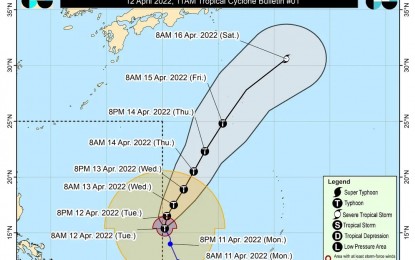
MANILA -- Typhoon Malakas has entered the Philippine Area of Responsibility (PAR) and was given the local name "Basyang," the weather bureau said in an update posted Tuesday noon.
The typhoon entered PAR at 10 a.m. but is not expected to have a direct effect on the country's weather, according to the Philippine Atmospheric, Geophysical and Astronomical Services Administration (PAGASA).
"Basyang" is also unlikely to directly affect the coastal waters' sea condition, but swells resulting from the typhoon is forecast to generate moderate to rough seas over the northern and eastern seaboards of Luzon, as well as the eastern seaboards of the Visayas and Mindanao.
The typhoon was last tracked 1,435 kilometers east of southern Luzon, and is forecast to exit PAR in the evening.
Meanwhile, Tropical Depression (TD) Agaton is now in the vicinity of Balangiga, Eastern Samar, and slowly moving eastward.
The TD packs maximum sustained winds of 45 kph near the center, and gustiness of up to 75 kph.
Tropical Cyclone Wind Signal No. 1 remains hoisted over the southern portion of Masbate (Dimasalang, Cawayan, Palanas, Placer, Cataingan, Esperanza, Pio V. Corpuz), Eastern Samar, Samar, Northern Samar, Biliran, Leyte, Southern Leyte, and the northeastern portion of Cebu (Daanbantayan, Medellin, City of Bogo, Tabogon, Borbon, Sogod) including Camotes Island, and Dinagat Islands.
Strong breeze to near gale conditions, and rough seas continue to prevail in these areas.
Moderate to rough seas are forecast over the remaining seaboards of the country that are not under any wind signal, especially over the northern and eastern seaboards of Luzon and the eastern seaboards of the Visayas and Mindanao.
PAGASA reiterated that these conditions may be risky for those using small seacraft. Mariners are advised to take precautionary measures when venturing out to the sea.
"Agaton" continues to bring moderate to heavy, with at times intense rains over Eastern Visayas, Bicol Region, the northern and central portions of Cebu including Bantayan and Camotes Islands, Aklan, Capiz, Iloilo, Antique, Guimaras, and the northern and central portions of Negros provinces.
Light to moderate, with at times heavy rains will continue to prevail over Mimaropa, Dinagat Islands, Zamboanga del Norte, Quezon, and the rest of the Visayas.
Scattered to widespread flooding and rain-induced landslides are likely, especially in areas highly susceptible to these hazards. (PNA)
