(PNA file photo)
MANILA – Some areas in Northern Luzon will still experience stormy weather even as Severe Tropical Storm (STS) Florita slightly weakened, the weather bureau said Tuesday afternoon.
In its 5 p.m. bulletin, the Philippine Atmospheric, Geophysical and Astronomical Services Administration (PAGASA) said stormy weather will prevail over the Cordillera Administrative Region and the Cagayan Valley Region, as well as the provinces of Ilocos Norte, Ilocos Sur and Aurora.
Heavy to intense, with at times torrential rains are also forecast over Babuyan Islands, Zambales, and Bataan.
Flash floods or landslides are possible due to heavy to torrential rains. Moderate to heavy damage to structures and vegetation are also likely due to damaging to destructive storm-force winds, PAGASA said.
Rains with gusty winds are expected in Batanes, La Union, Tarlac and Nueva Ecija. These areas may experience flash floods or landslides due to moderate to heavy rains. Very light to light damage to structures and vegetation are also possible due to moderate to strong winds.
"Florita" was last tracked in the vicinity of Kabugao, Apayao, moving northwestward at 20 kph.
It packs maximum sustained winds of 100 kph near the center, and gustiness of up to 125 kph.
Signal No. 3 remains hoisted over Ilocos Norte, Apayao, the southern portion of Babuyan Islands (Camiguin Is., Fuga Is., Dalupiri Is.), and mainland Cagayan.
Areas under Signal No. 2 are Ifugao, Mountain Province, Kalinga, Abra, Ilocos Sur and the rest of Babuyan Islands.
Signal No. 1 has been hoisted over La Union, the eastern portion of Pangasinan (Umingan, San Fabian, Sison, Pozorrubio, San Jacinto, Laoac, Binalonan, San Manuel, Asingan, Tayug, Santa Maria, San Quintin, Natividad, San Nicolas), Benguet, Nueva Vizcaya, Quirino, the northern portion of Nueva Ecija (Carranglan, Lupao, San Jose City, Pantabangan), and the northern and central portions of Aurora (Maria Aurora, Dipaculao, Dinalungan, Casiguran, Dilasag.
Winds may reach storm-force in strength in areas under Signal No. 3, while winds may reach gale-force in strength in areas under Signal No. 2. Strong breeze to near gale strength winds will be experienced in areas where Signal No. 1 has been hoisted.
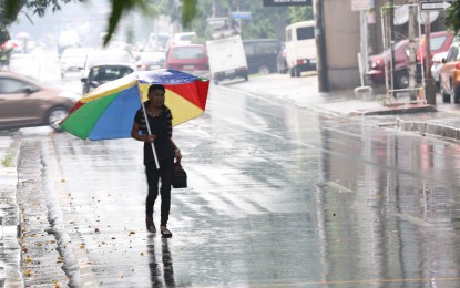
Meanwhile, moderate to heavy rains will continue over Metro Manila, Isabela, Tarlac, Pampanga, Cavite, and the rest of Cagayan Valley.
Light to moderate, with at times heavy rains will prevail over the rest of Central Luzon and Calabarzon.
Rough to high seas are forecast over the seaboards of Northern Luzon ( Ilocos Norte, Ilocos Sur, Batanes, Cagayan, and Isabela).
Rough to very rough seas will prevail over the western seaboard of Northern Luzon, the eastern seaboard of Central Luzon (La Union, Pangasinan, And Aurora), and the western seaboard of Central Luzon (Zambales And Bataan).
Rough seas will be experienced over the seaboards of Southern Luzon and the western seaboard of the Visayas (Quezon Including Polillo Island, Camarines Norte, Camarines Sur, Catanduanes, Cavite, western coast of Batangas, Occidental Mindoro, Oriental Mindoro, Marinduque, Romblon, Palawan, Antique and Aklan).
Rough to high sea conditions are risky for all types of sea vessels. PAGASA advised mariners to remain in port or take shelter in port until winds and waves subside.
For rough to very rough sea conditions, fishing boats and other small seagoing vessels are advised not to venture out into the sea, while larger sea vessels are alerted against big waves. (PNA)
