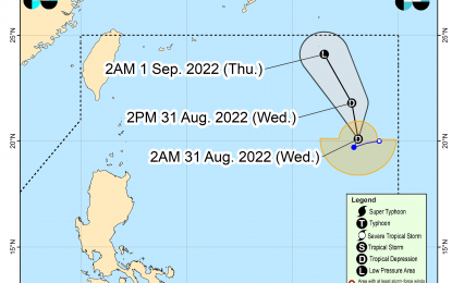
Track of Tropical Depression Gardo (Image from PAGASA)
MANILA – Tropical Depression Gardo meanders over the Philippine Sea and is now moving northeast but is unlikely to directly affect the country's weather condition, the weather bureau said Wednesday.
In its 5 a.m. tropical cyclone bulletin, the Philippine Atmospheric, Geophysical and Astronomical Services Administration said "Gardo" is forecast to move northwest as it interacts with Super Typhoon Hinnamnor, which is outside the Philippine Area of Responsibility (PAR).
“'Gardo' will degenerate into a remnant low this afternoon or evening as 'Hinnamnor' begins to assimilate its circulation," the bulletin read.
The center of the eye of "Gardo" was spotted at 1,130 km. east of extreme northern Luzon and moving at 10 kph with maximum sustained winds of 55 kph near the center and gustiness of up to 70 kph.
PAGASA is also monitoring "Hinnamnor" which could enter PAR either by Wednesday evening or Thursday.
Once inside PAR, it will be named "Henry".
Weather forecaster Grace Castañeda said "Hinnamnor" is unlikely to make landfall on any part of the country.
"Hinnamnor" packs maximum sustained winds of 195 kph and gustiness of up to 240 kph.
PAGASA forecast partly cloudy to cloudy skies with isolated rain showers or thunderstorms to prevail across the archipelago.
Light to moderate winds and slight to moderate seas will also continue to prevail over the entire country. (PNA)
