(Image courtesy of PAGASA)
MANILA – Many areas in Luzon will continue to experience the southwest monsoon or “habagat” caused by Typhoon Henry, the weather bureau said Friday afternoon.
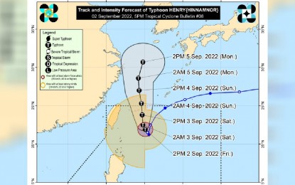
Even though "Henry" continues to weaken, it is still forecast to bring stormy weather over Batanes, where Tropical Cyclone Wind Signal No. 1 is still hoisted.
The Babuyan Islands and Cagayan will also experience rains with gusty winds due to the typhoon.
Residents of these areas could expect moderate to heavy damage to structures and vegetation due to damaging to destructive storm-force winds, the Philippine Atmospheric, Geophysical and Astronomical Services Administration (PAGASA) said.
"Henry" and the “habagat” will cause scattered rain showers and thunderstorms over Metro Manila, the Ilocos region, the rest of Cagayan Valley, the Cordillera region, Central Luzon, Calabarzon, and Mimaropa.
By Friday night, moderate to heavy rains may be experienced over Ilocos Norte, Batanes, the Babuyan Islands, and Abra.
Light to moderate, with at times heavy rains are likely over Cagayan, and the rest of Ilocos and Cordillera.
Strong to gale force winds, and rough to very rough seas will prevail over the northern and eastern seaboards of northern Luzon (Batanes, Cagayan Including the Babuyan Islands, Isabela, and Ilocos Norte), and the eastern seaboard of Central Luzon (Aurora).
Fishing boats and other small vessels are advised not to venture out into the sea, while larger sea vessels are alerted against big waves.
"Henry" was last tracked at 350 km. east-northeast of Itbayat, Batanes, moving northwestward at 10 kph.
The typhoon packs maximum sustained winds of 155 kph near the center and gustiness of up to 190 kph.
It is forecast to further weaken in the next 12 hours and exit the Philippine Area of Responsibility either Saturday or Sunday. (PNA)
