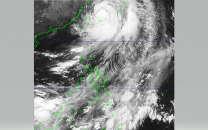
(Image courtesy of DOST/PAGASA)
MANILA – Typhoon Hinnamnor (formerly Typhoon Henry) exited the Philippine Area of Responsibility at 1:40 a.m. Sunday but still expected to enhance southwest monsoon or “habagat”.
In its 5 a.m. bulletin, the Philippine Atmospheric, Geophysical and Astronomical Services Administration (PAGASA) said “Hinnamnor” is now 565 kilometers north northeast of Itbayat, Batanes with maximum sustained winds of 150 kph near the center and gustiness of up to 185 kph.
It said “Hinnamnor” is forecast to move generally northward or north northwestward over the East China Sea.
Metro Manila, Ilocos Region, Batanes, Babuyan Islands, Abra, Benguet, Zambales, Bataan, Tarlac, Pampanga, Nueva Ecija, Bulacan, Cavite, Batangas, and Occidental Mindoro will experience cloudy skies with scattered rain showers and thunderstorms due to trough of “Hinnamnor” and southwest monsoon.
These areas, the weather bureau said, are warned against possible flash floods or landslides due to moderate to at times heavy rains.
Davao and Soccsksargen regions will also have cloudy skies with scattered rain showers and thunderstorms due to intertropical convergence zone that may also cause possible flash floods or landslides.
The rest of the country will experience partly cloudy to cloudy skies with isolated rain showers or thunderstorms due to “habagat” or localized thunderstorms.
“Despite the lifting of Tropical Cyclone Wind Signals, the enhanced southwest monsoon, its convergence with typhoon circulation, and the channeling of winds within the Luzon Straight will continue bringing strong winds (strong breeze to near gale strength) with guts reaching gale-force strengthen at times over Batanes and Babuyan Islands today,” the PAGASA said.
The temperature ranges between 24.3 °C and 28.0 °C. (PNA)
