(Image courtesy of PAGASA/DOST)
MANILA – Typhoon Inday has intensified further but remains less likely to directly bring heavy rains in the country, the Philippine Atmospheric, Geophysical and Astronomical Services Administration (PAGASA) said on Sunday.
In its 5 a.m. tropical cyclone bulletin, the weather bureau said “Inday”, however, slightly enhanced southwest monsoon or “habagat” that may bring rain showers and thunderstorms over Batanes and western sections Central and Southern Luzon.
Metro Manila and the rest of the country will have partly cloudy to cloudy skies with isolated rain showers or thunderstorms due southwest monsoon and localized thunderstorms.
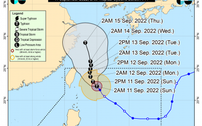
The eye of the typhoon is located 360 kilometers east northeast of Itbayat, Batanes with maximum sustained winds of 150 kph near the center and gustiness of up to 190 kph while moving northwestward at 15 kph.
“The latest forecast scenario for ‘Inday’ shows that while the hoisting of Tropical Cyclone Wind Signals remains less likely at this time, further westward shift in the track forecast and/or expansion in the extent of tropical cyclone winds may result in the hoisting of wind signals over portions of extreme Northern Luzon,” PAGASA said.
It added that gusty conditions reaching strong to gale-force strength may be experienced over extreme Northern Luzon on Monday due to the channeling of the typhoon circulation in the Luzon Strait.
The weather bureau said “Inday” is forecast to move generally northwestward over the Philippine Sea east of Taiwan Sunday through Monday afternoon and may exit the Philippine Area of Responsibility on Tuesday.
The temperature ranges between 25.0 °C and 27.6 °C. (PNA)
