(Screengrab from PAGASA Facebook live video)
MANILA – Typhoon Nanmadol is expected to enter the Philippine Area of Responsibility (PAR) on Friday noon, the weather bureau said.
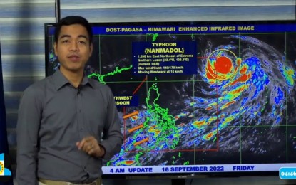
In a 4 a.m. weather bulletin, Benison Estareja, weather forecaster of the Philippine Atmospheric, Geophysical and Astronomical Services Administration (PAGASA), said “Nanmadol” was last tracked 1,530 km. east of extreme Northern Luzon, packing maximum sustained winds of up to 140 km. per hour (kph) near the center and gustiness of up to 170 kph.
Moving west at 15 kph, the typhoon will be given the local name “Josie” once it enters the PAR.
While it has no direct effect on the country's weather conditions, Estareja said “Nanmadol” is expected to enhance the southwest monsoon (habagat) that might bring rains over parts of the country.
PAGASA said Mimaropa, Bicol Region, and Western Visayas will experience cloudy skies with scattered rainshowers and thunderstorms due to the southwest monsoon.
Metro Manila and the rest of the country will have partly cloudy to cloudy skies with isolated rainshowers or thunderstorms.
Residents are also cautioned against possible flash floods or landslides due to moderate to at times heavy rains and thunderstorms. (PNA)
