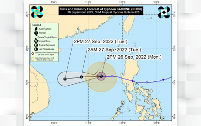
Track of Typhoon “Karding” (Image courtesy of PAGASA)
MANILA – Typhoon Karding slightly intensified as it is expected to exit the Philippine Area of Responsibility by Monday night, the weather bureau said.
"Karding" now packs maximum sustained winds of 140 kilometers per hour (kph) near the center, and gustiness of up to 170 kph.
No tropical cyclone wind signal was hoisted on any part of the country.
The typhoon was last located 425 kilometers west of Dagupan City, Pangasinan, moving westward at 30 kph.
Scattered rain showers and thunderstorms are forecast over Metro Manila, Western Visayas, Pangasinan, Zambales, Bataan, Cavite, Batangas, Aurora and Quezon due to the southwest monsoon and the trough of "Karding".
The Philippine Atmospheric, Geophysical and Astronomical Services Administration (PAGASA) also expects monsoon rains over Palawan.
Flash floods or landslides are likely in these areas due to moderate to at times heavy rains.
Meanwhile, "Karding" and the enhanced southwest monsoon will cause moderate to rough seas over the western seaboards of the country. These conditions may be risky for those using small sea vessels.
PAGASA advised mariners to take precautionary measures when venturing out to the sea. (PNA)
