(Image courtesy of PAGASA)
MANILA – Several areas in Luzon are now under Tropical Cyclone Wind Signal (TCWS) No. 1 due to Tropical Depression (TD) Maymay, the weather bureau said Tuesday.
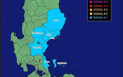
In its latest weather update, the Philippine Atmospheric, Geophysical and Astronomical Services Administration (PAGASA) said these areas are Isabela, Quirino, Nueva Vizcaya, Aurora, Nueva Ecija, and the extreme northern portion of Quezon (General Nakar, Infanta) including Polillo Islands.
"Maymay" packs maximum sustained winds of 45 kilometers per hour near the center and wind gusts of up to 55 kph. It was last tracked 300 km. east of Casiguran, Aurora, moving southwest at 10 kph.
Moderate to heavy rain showers are forecast over the provinces of Cagayan, Isabela and Apayao.
Light to moderate, with at times heavy rains are likely over Batanes, Ilocos Norte, Aurora, and Kalinga.
Scattered to widespread flooding and rain-induced landslides are expected, especially in areas highly susceptible to these hazards, PAGASA said.
Meanwhile, rough to very seas are forecast over the seaboards of northern Luzon (Batanes, Ilocos Norte, Cagayan And Isabela); western seaboard of northern Luzon, and the eastern seaboards of central and southern Luzon (Ilocos Sur, Aurora and the eastern coast of Polillo Island, Jomalig and Patnanungan).
PAGASA advised fishing boats and other small seacraft not to venture out into the sea and larger sea vessels are alerted against big waves.
"Maymay" may decelerate and generally move southwest in the next 48 hours.
It is forecast to make landfall in the vicinity of the southern portion of Aurora, or northern portion of Quezon on Wednesday. (PNA)
