(Courtesy of DOST-PAGASA)
MANILA – “Neneng” made landfall over Calayan Island, Cagayan after intensifying into a severe tropical storm, the Philippine Atmospheric Geophysical and Astronomical Services Administration (PAGASA) said Sunday.
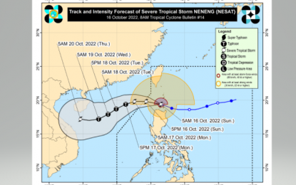
In its 5 a.m. tropical cyclone bulletin, the weather bureau said “Neneng” was located over the coastal waters of Calayan, Cagayan at 3 a.m. with maximum sustained winds of 95 kilometers per hour near the center and gustiness of up to 115 kph, moving west northwestward at 20 kph.
PAGASA said “Neneng” reached severe tropical storm category at 2 a.m. Sunday and " is likely" to further intensify into a typhoon.
Tropical Cyclone Wind Signal (TCWS) No. 3 was hoisted over the southern portion of Batanes (Basco, Mahatao, Uyugan, Ivana, Sabtang) and Babuyan Islands.
The rest of Batanes, the rest of Cagayan, Apayao, the northern portion of Abra (Tineg, Lacub, Lagayan), and Ilocos Norte are under TCWS No. 2.
Areas placed under Signal No. 1 were the northern and central portions of Isabela (Santa Maria, San Pablo, Maconacon, Divilacan, Palanan, Ilagan City, Tumauini, Cabagan, Santo Tomas, Quezon, Delfin Albano, Mallig, Quirino, Gamu, Roxas, San Mariano, Benito Soliven, Naguilian, Burgos, Reina Mercedes, San Manuel, Aurora, Luna, Cabatuan, San Mateo, Dinapigue, City of Cauayan), Kalinga, the rest of Abra, Mountain Province, the northern portion of Ifugao (Aguinaldo, Alfonso Lista, Mayoyao, Hungduan, Banaue), and the northern and central portions of Ilocos Sur (Sinait, Cabugao, San Juan, Magsingal, Santo Domingo, San Ildefonso, San Vicente, Santa Catalina, Bantay, City of Vigan, Santa, Caoayan, Narvacan, Nagbukel, Santa Maria, San Esteban, Santiago, Burgos, Banayoyo, Lidlidda, San Emilio, Quirino, Gregorio del Pilar, Galimuyod, City of Candon, Santa Lucia, Salcedo, Cervantes, Suyo, Sigay, Santa Cruz)
The weather bureau said Apayao, Ilocos Norte, and the northern portion of Cagayan including Babuyan Islands are likely to experience heavy to intense at times torrential rains until noon Sunday.
“Under these conditions, scattered to widespread flooding and rain-induced landslides are likely, especially in areas that are highly or very highly susceptible to these hazard as identified in hazard maps and in localities with significant antecedent rainfall,” it added.
It said the trough of “Neneng” and the convergence of its circulation with the southwesterly winds induced by the tropical storm may also bring occasional rains today over the western portions of Visayas and Mimorapa and the northern and western portions of Mindanao.
During the passage of “Neneng”, winds may reach storm-force strength in Babuyan Islands and southern Batanes.
The storm is forecast to exit the Philippine Area of Responsibility (PAR) Sunday night or early Monday morning “as it moves over the northern portion of the West Philippine Sea.” (PNA)
