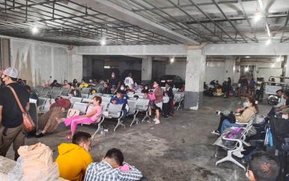
Stranded passengers at Batangas City port (Courtesy of Batangas-PIO)
MANILA – Severe Tropical Storm Paeng slightly decelerated as it is expected to make its fifth landfall in the province of Batangas on Saturday.
Paeng was last tracked over the coastal waters of San Juan, Batangas, according to the 2 p.m. severe weather bulletin of the Philippine Atmospheric, Geophysical and Astronomical Services Administration (PAGASA).
Paeng has maximum sustained winds of 95 kph near the center and gustiness of up to 130 kph. It is now moving west northwest at 15 kph.
The cyclone will make landfall in the vicinity of San Juan town before traversing the Cavite-Metro Manila-Bataan Peninsula area for the remainder of the day.
Paeng made landfall in Virac, Catanduanes at 1:10 a.m.; Caramoan, Camarines Sur at 1:40 a.m.; Buenavista, Quezon at 6 a.m.; and Santa Cruz, Marinduque at 8:40 a.m.
Tropical Cyclone Wind Signal (TCWS) No. 3 is hoisted over Metro Manila, Bataan, the southern portion of Zambales (Olongapo City, Subic, Castillejos, San Antonio), Marinduque, the northern and central portions of Quezon (Pitogo, Lucena City, Pagbilao, Infanta, Tiaong, Unisan, Plaridel, San Antonio, Candelaria, Lucban, Sampaloc, Padre Burgos, Sariaya, City of Tayabas, Mauban, Dolores, General Nakar, Agdangan, Gumaca, Atimonan, Real, Macalelon, General Luna, Catanauan) including Pollilo Islands, Laguna, Batangas, Cavite, Rizal, the northwestern portion of Occidental Mindoro (Paluan, Abra de Ilog) including Lubang Islands, and the northern portion of Oriental Mindoro (San Teodoro, Puerto Galera, Baco, City of Calapan, Naujan).
Areas under TCWS No. 3 will experience winds of greater than 89 kph to 117 kph in the next 18 hours.
TCWS No. 2 is raised over the southern portion of Aurora (San Luis, Baler, Dingalan, Maria Aurora), Bulacan, Nueva Ecija, Pangasinan, Pampanga, Tarlac, the rest of Zambales, the western and northwestern portions of Camarines Sur (Siruma, Tinambac, Ocampo, Goa, Lagonoy, Milaor, Nabua, Buhi, Baao, Bato, Camaligan, Pili, Tigaon, Garchitorena, Iriga City, San Fernando, Magarao, Minalabac, Balatan, Naga City, Calabanga, Bombon, Bula, Canaman, Saglay, San Jose, Gainza, Sipocot, Del Gallego, Ragay, Lupi, Pasacao, Cabusao, Libmanan, Pamplona), the rest of Oriental Mindoro, the rest of Occidental Mindoro, Romblon, Camarines Norte, the rest of Quezon, the northern and central portions of Albay (Tiwi, Malinao, Libon, City of Tabaco, Polangui, Oas, City of Ligao, Guinobatan, Pio Duran), and Burias Island.
In the Visayas, TCWS No. 2 is in effect over the northwestern portion of Antique (Libertad, Pandan, Caluya Islands) and the western portion of Aklan (Buruanga, Malay, Nabas, Ibajay, Tangalan, Makato, Numancia, Lezo).
Areas under TCWS No. 2 will experience winds of greater than 62 kph and up to 88 kph in the next 24 hours.
TCWS No. 1 is hoisted over the provinces of Isabela, Nueva Vizcaya, Quirino, La Union, Kalinga, Abra, Benguet, Ifugao, Mountain Province, Ilocos Sur, the rest of Aurora, Catanduanes, the rest of Camarines Sur, the rest of Albay, Sorsogon, the rest of Masbate including Ticao Island, and the northern portion of Palawan (El Nido, Taytay, Dumaran, Araceli, Roxas, San Vicente) including Calamian Islands and Cuyo Islands
Areas in the Visayas that are under TCWS No. 1 are the northern and central portions of Eastern Samar (Quinapondan, Can-Avid, Lawaan, Maslog, Balangiga, City of Borongan, San Policarpo, Taft, Llorente, Maydolong, Dolores, Giporlos, Jipapad, Oras, Arteche, Balangkayan, Sulat, San Julian, General Macarthur, Hernani), Samar, Northern Samar, Leyte, the northern and central portions of Cebu (Daanbantayan, Medellin, San Remigio, Tabogon, City of Bogo, Borbon, Tabuelan, Sogod, Catmon, Tuburan, Carmen, Danao City, Asturias, Balamban, Compostela, Liloan, Cebu City, Mandaue City, Consolacion, Toledo City, City of Talisay, City of Naga, Pinamungahan, Minglanilla, Aloguinsan, San Fernando, City of Carcar, Barili, Sibonga, Dumanjug, Argao, Alcantara, Moalboal, Ronda, Lapu-Lapu City, Cordova, Badian, Dalaguete) including Bantayan and Camotes Islands, Biliran, the northern portion of Bohol (Talibon, Getafe, Buenavista, Inabanga, Clarin, Tubigon, Calape, Bien Unido, Loon), Negros Occidental, the northern and central portions of Negros Oriental (City of Guihulngan, Vallehermoso, Canlaon City, La Libertad, Jimalalud, Tayasan, Bais City, City of Bayawan, Manjuyod, Basay, Bindoy, Mabinay, Ayungon, City of Tanjay), Guimaras, the rest of Antique, the rest of Aklan, Capiz, and Iloilo.
Winds of 39 to 61 kph may be expected in at least 36 hours or intermittent rains may be expected within 36 hours in areas under TCWS No. 1.
Metro Manila, Calabarzon, Bicol Region, Marinduque, Romblon, Mindoro Provinces, and the northern portion of Palawan including Calamian and Cuyo Islands will experience heavy to intense with at times torrential rains on Saturday afternoon.
Meanwhile, moderate to heavy with at times intense rains are likely over mainland Cagayan Valley, Cordillera Administrative Region, Western Visayas, and Central Luzon. Light to moderate with at times heavy rains possible over the rest of Luzon and Visayas.
On Sunday, moderate to heavy with at times intense rains likely over Zambales, Bataan, and Ilocos Region.
Light to moderate with at times heavy rains possible over Metro Manila, Mimaropa, Calabarzon, and the rest of Central Luzon. (PNA)
