(Image courtesy of PAGASA)
MANILA – Severe Tropical Storm Paeng is forecast to exit the Philippine Area of Responsibility (PAR) on Monday afternoon or evening.
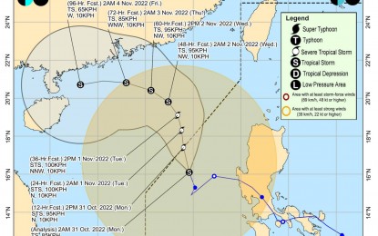
"Paeng is now moving towards the northwestern limit of PAR," the Philippine Atmospheric, Geophysical and Astronomical Services Administration (PAGASA) said in its 5 a.m. weather bulletin.
Paeng was last located 340 km. west of Dagupan City, Pangasinan. It packs maximum sustained winds of 85 kph near the center, and gustiness of up to 105 kph.
Tropical Cyclone Wind Signal No. 1 remains hoisted over Ilocos Norte, Ilocos Sur, La Union, Pangasinan, Apayao, Kalinga, Abra, Mountain Province, Ifugao, Benguet, Nueva Vizcaya, the western portion of Cagayan (Santa Praxedes, Claveria, Sanchez-Mira, Pamplona, Abulug, Ballesteros, Allacapan, Lasam, Santo Niño, Piat, Tuao, Rizal), the western portion of Isabela (Cordon, City of Santiago, San Mateo, Ramon, Alicia, San Isidro, Quezon, Mallig, Roxas, San Manuel, Aurora, Cabatuan), the northwestern portion of Quirino (Cabarroguis, Diffun, Saguday), the northern, western, and southern portions of Nueva Ecija (Cuyapo, City of Gapan, Talavera, San Leonardo, Santo Domingo, Rizal, San Isidro, Zaragoza, Llanera, Guimba, Aliaga, Science City of Muñoz, General Mamerto Natividad, Cabanatuan City, Carranglan, Quezon, San Antonio, San Jose City, Santa Rosa, Lupao, Nampicuan, Talugtug, Peñaranda, Jaen, Licab, Cabiao, Pantabangan), Pampanga, Bataan, Tarlac, Zambales, and the western portion of Bulacan (Hagonoy, Paombong, City of Malolos, Guiguinto, Calumpit, Pulilan, Plaridel, Baliuag, Bustos, San Miguel, San Ildefonso, San Rafael).
Strong breeze to near gale strength winds will prevail in those areas.
Paeng is also forecast to cause moderate to heavy rains over Batanes, Zambales, Bataan, Occidental Mindoro, and Palawan including Calamian and Cuyo Islands.
Light to moderate with at times heavy rains still possible over Ilocos Region, Cordillera Administrative Region, Metro Manila, Calabarzon, Western Visayas, Babuyan Islands, the rest of Central Luzon and Mimaropa.
It may cause moderate to rough seas over the western seaboard of the Visayas. These conditions may be risky for those using small seacraft.
PAGASA advised mariners to take precautionary measures when venturing to the sea and, if possible, avoid navigating in these conditions.
Meanwhile, PAGASA said the tropical depression tracked near Palau entered PAR at 5 a.m. Monday and has been given the local name Queenie.
Tropical cyclone bulletins for TD Queenie will be issued starting at 11 a.m. Monday. (PNA)
