(Image courtesy of PAGASA-DOST)
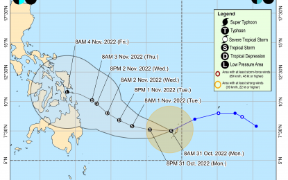
MANILA – Severe Tropical Storm Paeng exited the Philippine Area of Responsibility (PAR) early Monday afternoon, the Philippine Atmospheric, Geophysical and Astronomical Services Administration (PAGASA) said in its 5 p.m. weather bulletin.
The weather bureau said Paeng with international name Nalgae is now located 400 kilometers west of Sinait, Ilocos Norte with maximum sustained winds of 110 kilometers per hour and gustiness of up to 135 kph while moving northwestward at 15 kph.
Though Paeng left PAR at 12:10 p.m., it will continue to bring heavy rains with gusty winds, particularly in Ilocos Sur, La Union, Pangasinan and Zambales due to its wide circulation, PAGASA said.
Tropical Cyclone Wind Signal No. 1 remains hoisted over Abra, the western portion of Benguet (Tuba, Baguio City, Kapangan, Atok, Kibungan, La Trinidad, Sablan, Tublay, Bakun), the southern portion of Ilocos Norte (Badoc, Pinili, Banna, Nueva Era, City of Batac, Paoay, Marcos, Currimao, Dingras, Solsona, Sarrat, San Nicolas, Laoag City, Piddig), Ilocos Sur, La Union, the central and western portions of Pangasinan (Basista, Lingayen, Villasis, City of Alaminos, Anda, Malasiqui, San Fabian, Urbiztondo, Bautista, Mangaldan, Mapandan, Burgos, Dagupan City, Binalonan, Bolinao, Aguilar, Alcala, Sual, Labrador, Bani, Santo Tomas, Pozorrubio, City of Urdaneta, Laoac, Mangatarem, Mabini, San Carlos City, Manaoag, Binmaley, San Jacinto, Bugallon, Bayambang, Infanta, Agno, Calasiao, Santa Barbara, Dasol, Sison), the central and western portions of Tarlac (San Jose, Mayantoc, Capas, San Clemente, Santa Ignacia, Camiling, Moncada, Paniqui, Gerona, City of Tarlac, Bamban), and the northern and central portions Zambales (Botolan, Iba, Candelaria, Cabangan, Palauig, Santa Cruz, Masinloc, San Felipe)
“Under the influence of the surge of the northeast monsoon and Paeng, a marine gale warning remains in effect over most seaboards of Luzon,” the weather bureau said.
Meanwhile, PAGASA said Tropical Storm Queenie has accelerated west southwestward while maintaining its strength.
Queenie is located 695 km east southeast of Hinatuan, Surigao del Sur or 755 km east of Davao City.
It is moving west southwestward at 25 kph with maximum sustained winds of 65 kph near the center and gustiness of up to 80 kph.
PAGASA said Queenie is forecast to maintain its strengthen in the next 24 hours but “may weaken into a tropical depression by Tuesday morning or evening and further weakening into a remnant low is likely by Thursday or possibly earlier.”
It added that the tropical cyclone will bring light to moderate with at times heavy rains possible over Caraga, Eastern Visayas, and Davao Oriental Tuesday evening through Wednesday. (PNA)
